Donjimeno elevation
Donjimeno (Castille and León, Provincia de Ávila), Spain elevation is 885 meters and Donjimeno elevation in feet is 2904 ft above sea level [src 1]. Donjimeno is a seat of a third-order administrative division (feature code) with elevation that is 282 meters (925 ft) bigger than average city elevation in Spain.
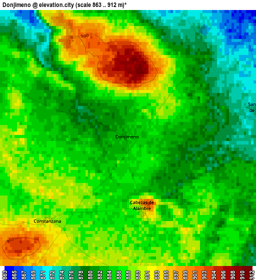
Below is the Elevation map of Donjimeno, which displays elevation range with different colors. Scale of the first map is from 863 to 912 m (2831 to 2992 ft) with average elevation of 885.1 meters (=2904 ft) [note 1]
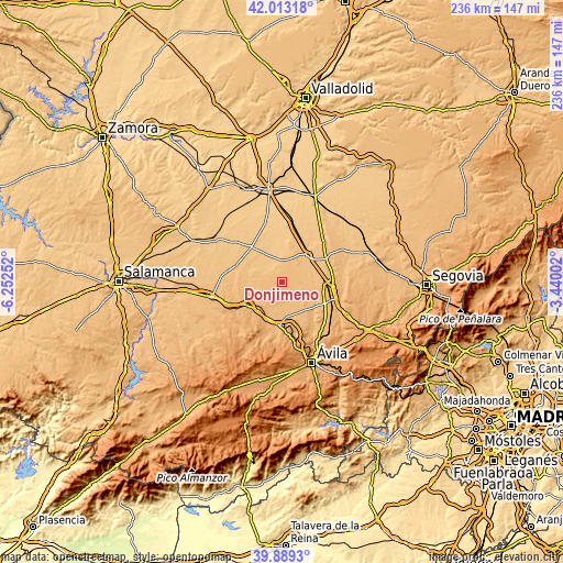
These maps also provides idea of topography and contour of this city, they are displayed at different zoom levels. More info about maps, scale and edge coordinates you can find below images.
| \ | Map #1 | Topo.Map |
| Scale [m] | 863..912 m | × |
| Scale [ft] | 2831..2992 ft | × |
| Average | 885.1 m = 2904 ft | × |
| Width | 7.38 km = 4.6 mi | 236.2 km = 146.8 mi |
| Height | 7.38 km = 4.6 mi | 236.1 km = 146.7 mi |
| ↑Max Latitude | 40.992958° | 42.01318° |
| Latitude at center | 40.95978° | 40.95978° |
| ↓Min Latitude | 40.926585° | 39.8893° |
| ← Min Longitude | -4.890215° | -6.25252° |
| Longitude center | -4.84627° | -4.84627° |
| →Max Longitude | -4.802325° | -3.44002° |
Nearby cities:
Cities around Donjimeno sort by population:
• Nava de Arévalo elevation 868 m
6.3 km,  71°
71°
• Langa 870 m
5.2 km,  347°
347°
• Aldeaseca 862 m
10.2 km,  13°
13°
• San Vicente de Arévalo 877 m
3.8 km,  76°
76°
• Cabezas de Alambre 899 m
2 km,  169°
169°
• Cantiveros 879 m
9.1 km,  264°
264°
• Fuentes de Año 824 m
7.8 km,  325°
325°
• Villanueva del Aceral 846 m
9 km,  355°
355°
• Constanzana 891 m
3.4 km,  225°
225°
• Narros de Saldueña 898 m
9.9 km,  191°
191°
• Cabizuela 887 m
7.5 km,  150°
150°
• Canales 857 m
6.7 km,  316°
316°
Multilingual:
 En español:
Donjimeno elevación 885 m.
 En France:
Donjimeno élévation 885 m.
 Auf Deutsch:
Donjimeno höhe über dem Meeresspiegel ist 885 m.

Sources and notes:
- [note 1] Map square and city borders are not equal. Map elevation data is calculated only from area inside that square.
- [src 1] Elevation data from geonames database provided with same terms of usage.
- [src 2] The elevation map of Donjimeno is generated using elevation data from NASA's 3 arcsec (90m) resolution SRTM data.
- [src 3] Base (background) map © OpenStreetMap contributors tiles are generated by Geofabrik and OpenTopoMap.
Copyright & License:
This Donjimeno Elevation Map is licensed under CC BY-SA. You may reuse any part from this page, if you give a proper credit by linking to this URL:
 More info on terms of use page.