el Raval elevation
el Raval (Catalonia, Província de Barcelona), Spain elevation is 21 meters and el Raval elevation in feet is 69 ft above sea level [src 1]. el Raval is a section of populated place (feature code) with elevation that is 582 meters (1909 ft) smaller than average city elevation in Spain.
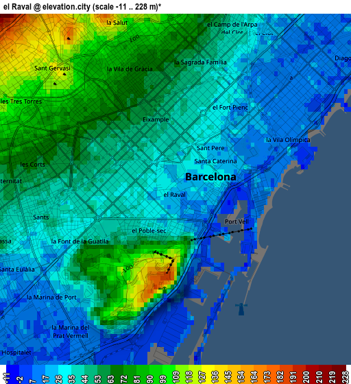
Below is the Elevation map of el Raval, which displays elevation range with different colors. Scale of the first map is from -11 to 228 m (-36 to 748 ft) with average elevation of 47 meters (=154 ft) [note 1]
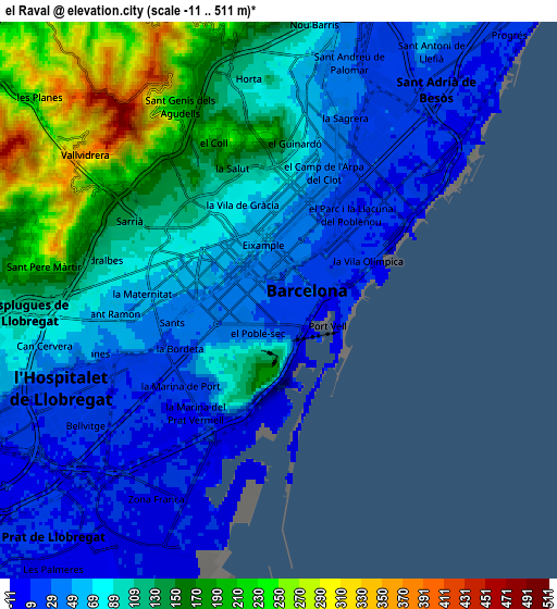
These maps also provides idea of topography and contour of this city, they are displayed at different zoom levels. More info about maps, scale and edge coordinates you can find below images.
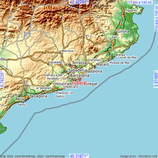
| \ | Map #1 | Map #2 | Topo.Map |
| Scale [m] | -11..228 m | -11..511 m | × |
| Scale [ft] | -36..748 ft | -36..1677 ft | × |
| Average | 47 m = 154 ft | 93.9 m = 308 ft | × |
| Width | 7.33 km = 4.6 mi | 14.67 km = 9.1 mi | 234.6 km = 145.8 mi |
| Height | 7.33 km = 4.6 mi | 14.67 km = 9.1 mi | 234.6 km = 145.8 mi |
| ↑Max Latitude | 41.413385° | 41.446334° | 42.42701° |
| Latitude at center | 41.38042° | 41.38042° | 41.38042° |
| ↓Min Latitude | 41.347438° | 41.314439° | 40.31671° |
| ← Min Longitude | 2.124655° | 2.080709° | 0.76235° |
| Longitude center | 2.1686° | 2.1686° | 2.1686° |
| →Max Longitude | 2.212545° | 2.256491° | 3.57485° |
Nearby cities:
Cities around el Raval sort by population:
• Barcelona elevation 47 m
1.2 km,  319°
319°
• Eixample 44 m
1.1 km,  329°
329°
• Sants-Montjuïc 44 m
1.5 km,  233°
233°
• Ciutat Vella 28 m
0.4 km,  93°
93°
• la Nova Esquerra de l'Eixample 45 m
1.7 km,  280°
280°
• Dreta de l'Eixample 48 m
1.7 km,  355°
355°
• l'Antiga Esquerra de l'Eixample 48 m
1.5 km,  311°
311°
• Poble Sec 31 m
0.8 km,  214°
214°
• Sant Antoni 35 m
0.8 km,  255°
255°
• Fort Pienc 30 m
1.8 km,  29°
29°
• Sant Pere, Santa Caterina i La Ribera 22 m
1.2 km,  67°
67°
• Barri Gòtic 29 m
0.7 km,  60°
60°
Multilingual:
 En español:
Barrio el Raval elevación 21 m.
 En France:
el Raval élévation 21 m.


Sources and notes:
- [note 1] Map square and city borders are not equal. Map elevation data is calculated only from area inside that square.
- [src 1] Elevation data from geonames database provided with same terms of usage.
- [src 2] The elevation map of el Raval is generated using elevation data from NASA's 3 arcsec (90m) resolution SRTM data.
- [src 3] Base (background) map © OpenStreetMap contributors tiles are generated by Geofabrik and OpenTopoMap.
Copyright & License:
This el Raval Elevation Map is licensed under CC BY-SA. You may reuse any part from this page, if you give a proper credit by linking to this URL:
 More info on terms of use page.