El Tiemblo elevation
El Tiemblo (Castille and León, Provincia de Ávila), Spain elevation is 692 meters and El Tiemblo elevation in feet is 2270 ft above sea level [src 1]. El Tiemblo is a populated place (feature code) with elevation that is 89 meters (292 ft) bigger than average city elevation in Spain.
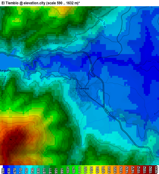
Below is the Elevation map of El Tiemblo, which displays elevation range with different colors. Scale of the first map is from 590 to 1632 m (1936 to 5354 ft) with average elevation of 851.1 meters (=2792 ft) [note 1]
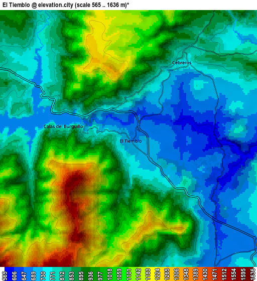
These maps also provides idea of topography and contour of this city, they are displayed at different zoom levels. More info about maps, scale and edge coordinates you can find below images.
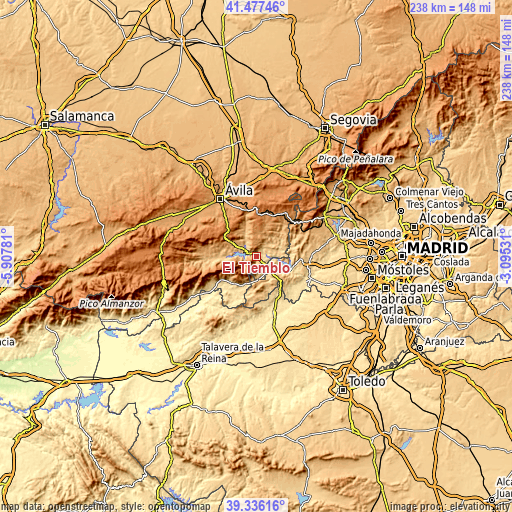
| \ | Map #1 | Map #2 | Topo.Map |
| Scale [m] | 590..1632 m | 565..1636 m | × |
| Scale [ft] | 1936..5354 ft | 1854..5367 ft | × |
| Average | 851.1 m = 2792 ft | 901 m = 2956 ft | × |
| Width | 7.44 km = 4.6 mi | 14.88 km = 9.2 mi | 238.1 km = 147.9 mi |
| Height | 7.44 km = 4.6 mi | 14.88 km = 9.2 mi | 238.1 km = 147.9 mi |
| ↑Max Latitude | 40.44878° | 40.482214° | 41.47746° |
| Latitude at center | 40.41533° | 40.41533° | 40.41533° |
| ↓Min Latitude | 40.381863° | 40.34838° | 39.33616° |
| ← Min Longitude | -4.545505° | -4.589451° | -5.90781° |
| Longitude center | -4.50156° | -4.50156° | -4.50156° |
| →Max Longitude | -4.457615° | -4.413669° | -3.09531° |
Nearby cities:
Cities around El Tiemblo sort by population:
• San Martín de Valdeiglesias elevation 675 m
10.6 km,  124°
124°
• Sotillo de la Adrada 634 m
15.5 km,  206°
206°
• Cebreros 775 m
5.7 km,  33°
33°
• El Hoyo de Pinares 851 m
11.6 km, 34°
• Pelayos de la Presa 560 m
15.4 km,  113°
113°
• Barraco 1021 m
13.8 km,  299°
299°
• Casillas 1048 m
11.6 km, 210°
• San Juan de la Nava 1130 m
16.8 km,  294°
294°
• Navahondilla 710 m
10 km,  177°
177°
• Santa Cruz de Pinares 1008 m
15.6 km,  334°
334°
• Cadalso de los Vidrios 807 m
14 km,  155°
155°
• Rozas de Puerto Real 870 m
11.1 km,  171°
171°
Multilingual:
 En español:
El Tiemblo elevación 692 m.
 En France:
El Tiemblo élévation 692 m.
 Auf Deutsch:
El Tiemblo höhe über dem Meeresspiegel ist 692 m.

Sources and notes:
- [note 1] Map square and city borders are not equal. Map elevation data is calculated only from area inside that square.
- [src 1] Elevation data from geonames database provided with same terms of usage.
- [src 2] The elevation map of El Tiemblo is generated using elevation data from NASA's 3 arcsec (90m) resolution SRTM data.
- [src 3] Base (background) map © OpenStreetMap contributors tiles are generated by Geofabrik and OpenTopoMap.
Copyright & License:
This El Tiemblo Elevation Map is licensed under CC BY-SA. You may reuse any part from this page, if you give a proper credit by linking to this URL:
 More info on terms of use page.