Endrinal elevation
Endrinal (Castille and León, Provincia de Salamanca), Spain elevation is 928 meters and Endrinal elevation in feet is 3045 ft above sea level [src 1]. Endrinal is a seat of a third-order administrative division (feature code) with elevation that is 325 meters (1066 ft) bigger than average city elevation in Spain.
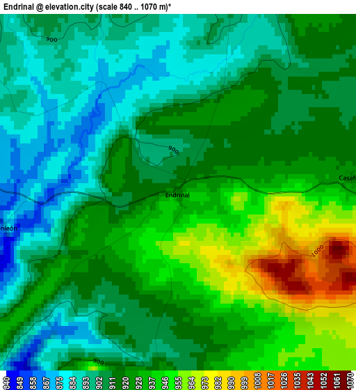
Below is the Elevation map of Endrinal, which displays elevation range with different colors. Scale of the first map is from 840 to 1070 m (2756 to 3510 ft) with average elevation of 917.6 meters (=3010 ft) [note 1]
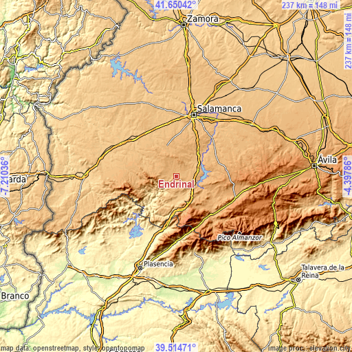
These maps also provides idea of topography and contour of this city, they are displayed at different zoom levels. More info about maps, scale and edge coordinates you can find below images.
| \ | Map #1 | Topo.Map |
| Scale [m] | 840..1070 m | × |
| Scale [ft] | 2756..3510 ft | × |
| Average | 917.6 m = 3010 ft | × |
| Width | 7.42 km = 4.6 mi | 237.5 km = 147.6 mi |
| Height | 7.42 km = 4.6 mi | 237.5 km = 147.6 mi |
| ↑Max Latitude | 40.624453° | 41.65042° |
| Latitude at center | 40.59109° | 40.59109° |
| ↓Min Latitude | 40.557711° | 39.51471° |
| ← Min Longitude | -5.848055° | -7.21036° |
| Longitude center | -5.80411° | -5.80411° |
| →Max Longitude | -5.760165° | -4.39786° |
Nearby cities:
Cities around Endrinal sort by population:
• Guijuelo elevation 1009 m
11.9 km,  108°
108°
• Linares de Riofrío 958 m
9.9 km,  265°
265°
• San Miguel de Valero 937 m
11.3 km,  242°
242°
• Valdelacasa 956 m
10 km,  160°
160°
• Fuenterroble de Salvatierra 951 m
6.6 km,  116°
116°
• Frades de la Sierra 954 m
7.5 km,  14°
14°
• Berrocal de Salvatierra 900 m
10.7 km,  64°
64°
• Monleón 872 m
3.4 km,  252°
252°
• Herguijuela del Campo 931 m
6.7 km,  311°
311°
• Membribe de la Sierra 1027 m
11.1 km,  359°
359°
• Casafranca 930 m
3.7 km,  87°
87°
• Puebla de San Medel 962 m
10.6 km,  147°
147°
Multilingual:
 En español:
Endrinal elevación 928 m.
 En France:
Endrinal élévation 928 m.
 Auf Deutsch:
Endrinal höhe über dem Meeresspiegel ist 928 m.

Sources and notes:
- [note 1] Map square and city borders are not equal. Map elevation data is calculated only from area inside that square.
- [src 1] Elevation data from geonames database provided with same terms of usage.
- [src 2] The elevation map of Endrinal is generated using elevation data from NASA's 3 arcsec (90m) resolution SRTM data.
- [src 3] Base (background) map © OpenStreetMap contributors tiles are generated by Geofabrik and OpenTopoMap.
Copyright & License:
This Endrinal Elevation Map is licensed under CC BY-SA. You may reuse any part from this page, if you give a proper credit by linking to this URL:
 More info on terms of use page.