Escopete elevation
Escopete (Castille-La Mancha, Provincia de Guadalajara), Spain elevation is 891 meters and Escopete elevation in feet is 2923 ft above sea level [src 1]. Escopete is a seat of a third-order administrative division (feature code) with elevation that is 288 meters (945 ft) bigger than average city elevation in Spain.
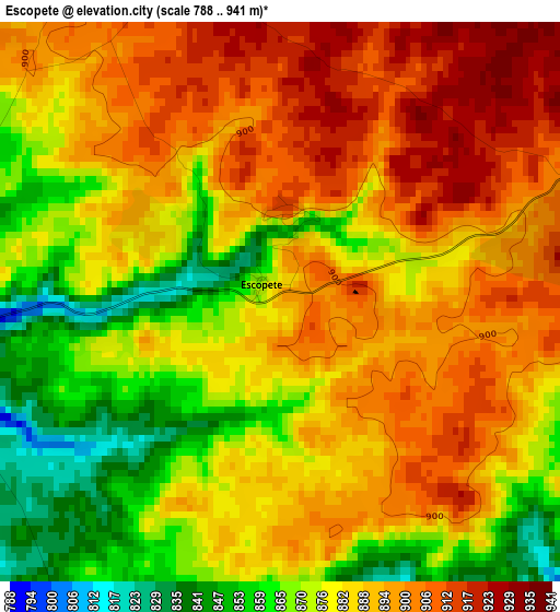
Below is the Elevation map of Escopete, which displays elevation range with different colors. Scale of the first map is from 788 to 941 m (2585 to 3087 ft) with average elevation of 884.9 meters (=2903 ft) [note 1]
These maps also provides idea of topography and contour of this city, they are displayed at different zoom levels. More info about maps, scale and edge coordinates you can find below images.
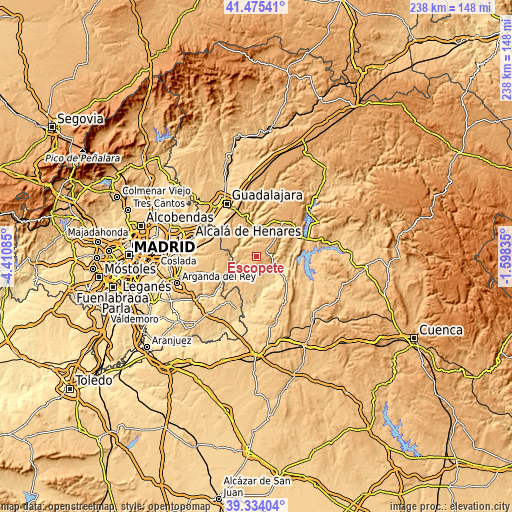
| \ | Map #1 | Topo.Map |
| Scale [m] | 788..941 m | × |
| Scale [ft] | 2585..3087 ft | × |
| Average | 884.9 m = 2903 ft | × |
| Width | 7.44 km = 4.6 mi | 238.1 km = 147.9 mi |
| Height | 7.44 km = 4.6 mi | 238.1 km = 147.9 mi |
| ↑Max Latitude | 40.446691° | 41.47541° |
| Latitude at center | 40.41324° | 40.41324° |
| ↓Min Latitude | 40.379772° | 39.33404° |
| ← Min Longitude | -3.048545° | -4.41085° |
| Longitude center | -3.0046° | -3.0046° |
| →Max Longitude | -2.960655° | -1.59835° |
Nearby cities:
Cities around Escopete sort by population:
• Pastrana elevation 778 m
7 km,  84°
84°
• Loranca de Tajuña 697 m
9.6 km,  290°
290°
• Yebra 750 m
7 km,  152°
152°
• Aranzueque 681 m
10.5 km,  325°
325°
• Fuentenovilla 798 m
9.2 km,  232°
232°
• Hontoba 761 m
5.4 km, 327°
• Escariche 826 m
4.2 km,  258°
258°
• Pozo de Almoguera 794 m
8.3 km,  192°
192°
• Hueva 897 m
6.6 km,  34°
34°
• Moratilla de los Meleros 839 m
11.2 km, 27°
• Renera 766 m
8.5 km,  354°
354°
• Valdeconcha 734 m
11.8 km,  66°
66°
Multilingual:
 En español:
Escopete elevación 891 m.
 En France:
Escopete élévation 891 m.
 Auf Deutsch:
Escopete höhe über dem Meeresspiegel ist 891 m.

Sources and notes:
- [note 1] Map square and city borders are not equal. Map elevation data is calculated only from area inside that square.
- [src 1] Elevation data from geonames database provided with same terms of usage.
- [src 2] The elevation map of Escopete is generated using elevation data from NASA's 3 arcsec (90m) resolution SRTM data.
- [src 3] Base (background) map © OpenStreetMap contributors tiles are generated by Geofabrik and OpenTopoMap.
Copyright & License:
This Escopete Elevation Map is licensed under CC BY-SA. You may reuse any part from this page, if you give a proper credit by linking to this URL:
 More info on terms of use page.