Fermoselle elevation
Fermoselle (Castille and León, Provincia de Zamora), Spain elevation is 701 meters and Fermoselle elevation in feet is 2300 ft above sea level [src 1]. Fermoselle is a seat of a third-order administrative division (feature code) with elevation that is 98 meters (322 ft) bigger than average city elevation in Spain.
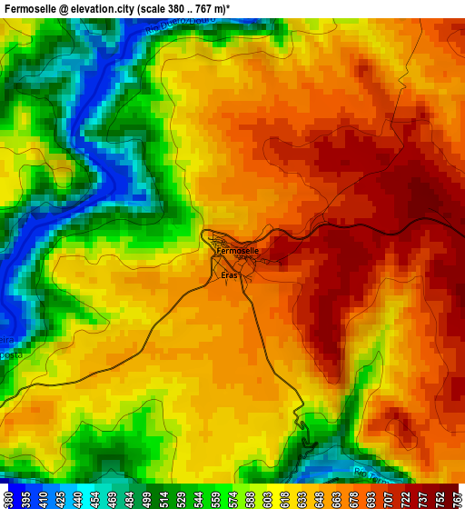
Below is the Elevation map of Fermoselle, which displays elevation range with different colors. Scale of the first map is from 380 to 767 m (1247 to 2516 ft) with average elevation of 617.1 meters (=2025 ft) [note 1]
These maps also provides idea of topography and contour of this city, they are displayed at different zoom levels. More info about maps, scale and edge coordinates you can find below images.
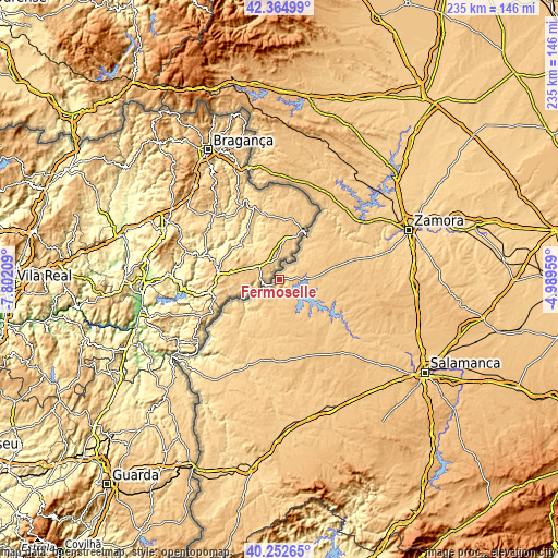
| \ | Map #1 | Topo.Map |
| Scale [m] | 380..767 m | × |
| Scale [ft] | 1247..2516 ft | × |
| Average | 617.1 m = 2025 ft | × |
| Width | 7.34 km = 4.6 mi | 234.9 km = 146 mi |
| Height | 7.34 km = 4.6 mi | 234.9 km = 146 mi |
| ↑Max Latitude | 41.350377° | 42.36499° |
| Latitude at center | 41.31738° | 41.31738° |
| ↓Min Latitude | 41.284366° | 40.25265° |
| ← Min Longitude | -6.439785° | -7.80209° |
| Longitude center | -6.39584° | -6.39584° |
| →Max Longitude | -6.351895° | -4.98959° |
Nearby cities:
Cities around Fermoselle sort by population:
• Villarino de los Aires elevation 604 m
8 km,  229°
229°
• Villar del Buey 772 m
17.3 km,  85°
85°
• Fariza 699 m
15.4 km,  44°
44°
• Muga de Sayago 782 m
18.3 km,  64°
64°
• Masueco 689 m
20.5 km, 231°
• Monleras 760 m
20.3 km,  135°
135°
• Trabanca 745 m
9.5 km,  174°
174°
• Almendra 765 m
10.8 km,  154°
154°
• Salce 745 m
15.7 km,  109°
109°
• Sardón de los Frailes 742 m
15.5 km, 137°
• Iruelos 785 m
20.4 km,  163°
163°
• Ahigal de Villarino 766 m
17.7 km,  175°
175°
Multilingual:
 En español:
Fermoselle elevación 701 m.
 En France:
Fermoselle élévation 701 m.
 Auf Deutsch:
Fermoselle höhe über dem Meeresspiegel ist 701 m.

Sources and notes:
- [note 1] Map square and city borders are not equal. Map elevation data is calculated only from area inside that square.
- [src 1] Elevation data from geonames database provided with same terms of usage.
- [src 2] The elevation map of Fermoselle is generated using elevation data from NASA's 3 arcsec (90m) resolution SRTM data.
- [src 3] Base (background) map © OpenStreetMap contributors tiles are generated by Geofabrik and OpenTopoMap.
Copyright & License:
This Fermoselle Elevation Map is licensed under CC BY-SA. You may reuse any part from this page, if you give a proper credit by linking to this URL:
 More info on terms of use page.