Figueruelas elevation
Figueruelas (Aragon, Provincia de Zaragoza), Spain elevation is 256 meters and Figueruelas elevation in feet is 840 ft above sea level [src 1]. Figueruelas is a seat of a third-order administrative division (feature code) with elevation that is 347 meters (1138 ft) smaller than average city elevation in Spain.
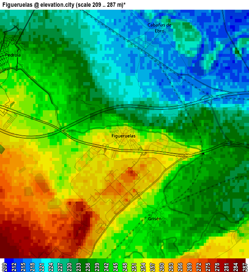
Below is the Elevation map of Figueruelas, which displays elevation range with different colors. Scale of the first map is from 209 to 287 m (686 to 942 ft) with average elevation of 241.2 meters (=791 ft) [note 1]
These maps also provides idea of topography and contour of this city, they are displayed at different zoom levels. More info about maps, scale and edge coordinates you can find below images.
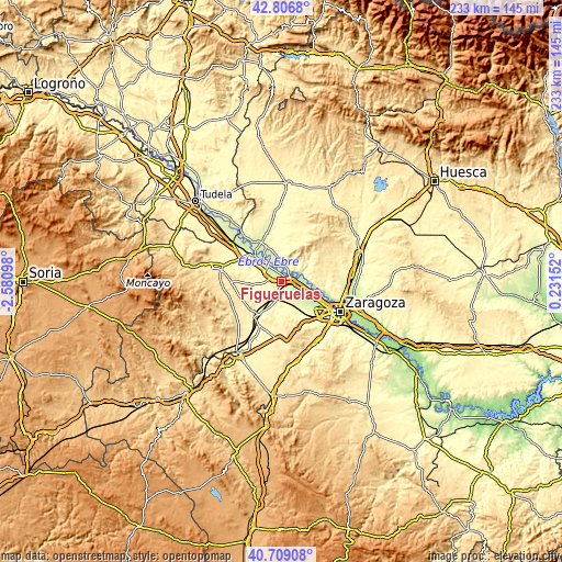
| \ | Map #1 | Topo.Map |
| Scale [m] | 209..287 m | × |
| Scale [ft] | 686..942 ft | × |
| Average | 241.2 m = 791 ft | × |
| Width | 7.29 km = 4.5 mi | 233.2 km = 144.9 mi |
| Height | 7.29 km = 4.5 mi | 233.2 km = 144.9 mi |
| ↑Max Latitude | 41.799279° | 42.8068° |
| Latitude at center | 41.76651° | 41.76651° |
| ↓Min Latitude | 41.733724° | 40.70908° |
| ← Min Longitude | -1.218675° | -2.58098° |
| Longitude center | -1.17473° | -1.17473° |
| →Max Longitude | -1.130785° | 0.23152° |
Nearby cities:
Cities around Figueruelas sort by population:
• Alagón elevation 232 m
4.6 km,  85°
85°
• Pedrola 238 m
4.2 km,  310°
310°
• Pinseque 230 m
7 km,  118°
118°
• Torres de Berrellén 216 m
9.1 km,  95°
95°
• Remolinos 230 m
8.1 km,  358°
358°
• Luceni 235 m
8.7 km,  322°
322°
• Cabañas de Ebro 226 m
4.3 km,  330°
330°
• Grisén 246 m
2.6 km,  156°
156°
• Bárboles 273 m
6.5 km,  188°
188°
• Bardallur 283 m
9.7 km,  198°
198°
• Alcalá de Ebro 226 m
5.6 km,  343°
343°
• Pleitas 259 m
6.6 km, 200°
Multilingual:
 En español:
Figueruelas elevación 256 m.
 En France:
Figueruelas élévation 256 m.
 Auf Deutsch:
Figueruelas höhe über dem Meeresspiegel ist 256 m.

Sources and notes:
- [note 1] Map square and city borders are not equal. Map elevation data is calculated only from area inside that square.
- [src 1] Elevation data from geonames database provided with same terms of usage.
- [src 2] The elevation map of Figueruelas is generated using elevation data from NASA's 3 arcsec (90m) resolution SRTM data.
- [src 3] Base (background) map © OpenStreetMap contributors tiles are generated by Geofabrik and OpenTopoMap.
Copyright & License:
This Figueruelas Elevation Map is licensed under CC BY-SA. You may reuse any part from this page, if you give a proper credit by linking to this URL:
 More info on terms of use page.