Fontanilles elevation
Fontanilles (Catalonia, Província de Girona), Spain elevation is 17 meters and Fontanilles elevation in feet is 56 ft above sea level [src 1]. Fontanilles is a seat of a third-order administrative division (feature code) with elevation that is 586 meters (1923 ft) smaller than average city elevation in Spain.
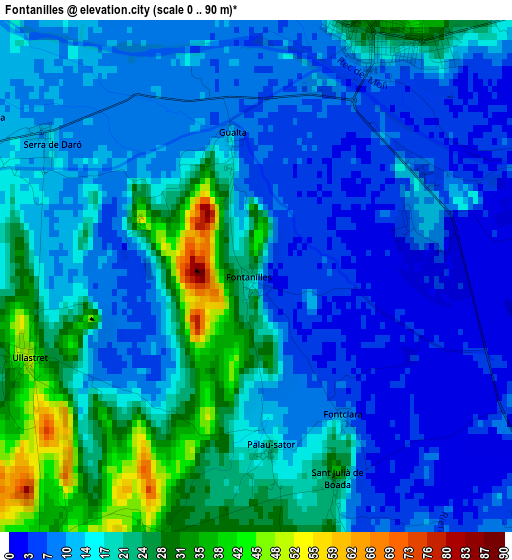
Below is the Elevation map of Fontanilles, which displays elevation range with different colors. Scale of the first map is from 0 to 90 m (0 to 295 ft) with average elevation of 15.4 meters (=51 ft) [note 1]
These maps also provides idea of topography and contour of this city, they are displayed at different zoom levels. More info about maps, scale and edge coordinates you can find below images.
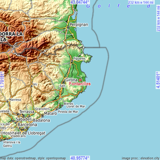
| \ | Map #1 | Topo.Map |
| Scale [m] | 0..90 m | × |
| Scale [ft] | 0..295 ft | × |
| Average | 15.4 m = 51 ft | × |
| Width | 7.26 km = 4.5 mi | 232.4 km = 144.4 mi |
| Height | 7.26 km = 4.5 mi | 232.3 km = 144.3 mi |
| ↑Max Latitude | 42.043814° | 43.04744° |
| Latitude at center | 42.01117° | 42.01117° |
| ↓Min Latitude | 41.97851° | 40.95774° |
| ← Min Longitude | 3.063815° | 1.70151° |
| Longitude center | 3.10776° | 3.10776° |
| →Max Longitude | 3.151705° | 4.51401° |
Nearby cities:
Cities around Fontanilles sort by population:
• Torroella de Montgrí elevation 29 m
3.8 km,  24°
24°
• Pals 20 m
5.6 km,  143°
143°
• Verges 20 m
7.7 km,  318°
318°
• Ullà 13 m
4.3 km,  359°
359°
• Gualta 14 m
2.1 km,  349°
349°
• Palau-sator 24 m
2.5 km,  175°
175°
• Rupià 50 m
7.5 km,  274°
274°
• Ultramort 27 m
6.7 km,  294°
294°
• Serra de Daró 14 m
3.5 km,  303°
303°
• Torrent 45 m
6.7 km,  166°
166°
• Parlavà 31 m
6.4 km,  280°
280°
• Ullastret 40 m
3.6 km,  249°
249°
Multilingual:
 En español:
Fontanillas elevación 17 m.
 En France:
Fontanilles élévation 17 m.
 Auf Deutsch:
Fontanilles höhe über dem Meeresspiegel ist 17 m.

Sources and notes:
- [note 1] Map square and city borders are not equal. Map elevation data is calculated only from area inside that square.
- [src 1] Elevation data from geonames database provided with same terms of usage.
- [src 2] The elevation map of Fontanilles is generated using elevation data from NASA's 3 arcsec (90m) resolution SRTM data.
- [src 3] Base (background) map © OpenStreetMap contributors tiles are generated by Geofabrik and OpenTopoMap.
Copyright & License:
This Fontanilles Elevation Map is licensed under CC BY-SA. You may reuse any part from this page, if you give a proper credit by linking to this URL:
 More info on terms of use page.