Fortanete elevation
Fortanete (Aragon, Provincia de Teruel), Spain elevation is 1355 meters and Fortanete elevation in feet is 4446 ft above sea level [src 1]. Fortanete is a seat of a third-order administrative division (feature code) with elevation that is 752 meters (2467 ft) bigger than average city elevation in Spain.
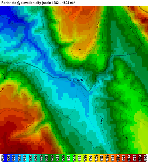
Below is the Elevation map of Fortanete, which displays elevation range with different colors. Scale of the first map is from 1282 to 1804 m (4206 to 5919 ft) with average elevation of 1493.9 meters (=4901 ft) [note 1]
These maps also provides idea of topography and contour of this city, they are displayed at different zoom levels. More info about maps, scale and edge coordinates you can find below images.
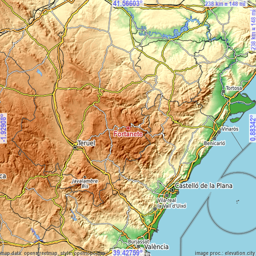
| \ | Map #1 | Topo.Map |
| Scale [m] | 1282..1804 m | × |
| Scale [ft] | 4206..5919 ft | × |
| Average | 1493.9 m = 4901 ft | × |
| Width | 7.43 km = 4.6 mi | 237.8 km = 147.8 mi |
| Height | 7.43 km = 4.6 mi | 237.8 km = 147.8 mi |
| ↑Max Latitude | 40.538735° | 41.56603° |
| Latitude at center | 40.50533° | 40.50533° |
| ↓Min Latitude | 40.471908° | 39.42759° |
| ← Min Longitude | -0.566775° | -1.92908° |
| Longitude center | -0.52283° | -0.52283° |
| →Max Longitude | -0.478885° | 0.88342° |
Nearby cities:
Cities around Fortanete sort by population:
• Cantavieja elevation 1297 m
10.2 km,  76°
76°
• Mosqueruela 1480 m
17.2 km,  158°
158°
• La Iglesuela del Cid 1233 m
17.4 km,  98°
98°
• Villarluengo 1121 m
15.9 km,  357°
357°
• Villarroya de los Pinares 1328 m
12.6 km,  282°
282°
• Allepuz 1472 m
17.1 km,  265°
265°
• Valdelinares 1682 m
14.5 km,  208°
208°
• Mirambel 922 m
17.7 km,  59°
59°
• Pitarque 1005 m
17 km,  339°
339°
• Tronchón 1109 m
16.6 km,  39°
39°
• Gúdar 1578 m
18.2 km,  246°
246°
• Cañada de Benatanduz 1437 m
8.3 km,  351°
351°
Multilingual:
 En español:
Fortanete elevación 1355 m.
 En France:
Fortanete élévation 1355 m.
 Auf Deutsch:
Fortanete höhe über dem Meeresspiegel ist 1355 m.

Sources and notes:
- [note 1] Map square and city borders are not equal. Map elevation data is calculated only from area inside that square.
- [src 1] Elevation data from geonames database provided with same terms of usage.
- [src 2] The elevation map of Fortanete is generated using elevation data from NASA's 3 arcsec (90m) resolution SRTM data.
- [src 3] Base (background) map © OpenStreetMap contributors tiles are generated by Geofabrik and OpenTopoMap.
Copyright & License:
This Fortanete Elevation Map is licensed under CC BY-SA. You may reuse any part from this page, if you give a proper credit by linking to this URL:
 More info on terms of use page.