Gallegos de Argañán elevation
Gallegos de Argañán (Castille and León, Provincia de Salamanca), Spain elevation is 662 meters and Gallegos de Argañán elevation in feet is 2172 ft above sea level [src 1]. Gallegos de Argañán is a seat of a third-order administrative division (feature code) with elevation that is 59 meters (194 ft) bigger than average city elevation in Spain.
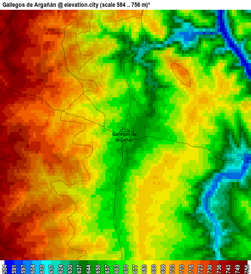
Below is the Elevation map of Gallegos de Argañán, which displays elevation range with different colors. Scale of the first map is from 584 to 756 m (1916 to 2480 ft) with average elevation of 683.8 meters (=2243 ft) [note 1]
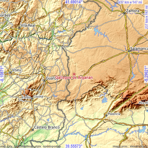
These maps also provides idea of topography and contour of this city, they are displayed at different zoom levels. More info about maps, scale and edge coordinates you can find below images.
| \ | Map #1 | Topo.Map |
| Scale [m] | 584..756 m | × |
| Scale [ft] | 1916..2480 ft | × |
| Average | 683.8 m = 2243 ft | × |
| Width | 7.42 km = 4.6 mi | 237.3 km = 147.5 mi |
| Height | 7.42 km = 4.6 mi | 237.3 km = 147.5 mi |
| ↑Max Latitude | 40.664802° | 41.69014° |
| Latitude at center | 40.63146° | 40.63146° |
| ↓Min Latitude | 40.598101° | 39.55573° |
| ← Min Longitude | -6.746405° | -8.10871° |
| Longitude center | -6.70246° | -6.70246° |
| →Max Longitude | -6.658515° | -5.29621° |
Nearby cities:
Cities around Gallegos de Argañán sort by population:
• Ciudad Rodrigo elevation 650 m
14.7 km,  103°
103°
• Fuentes de Oñoro 738 m
10.2 km,  243°
243°
• Aldea del Obispo 685 m
11.3 km,  317°
317°
• Villar de Ciervo 686 m
12.2 km,  345°
345°
• Castillejo de Martín Viejo 679 m
9.1 km,  36°
36°
• Ituero de Azaba 667 m
16.3 km,  177°
177°
• Espeja 699 m
7.4 km,  188°
188°
• Villar de la Yegua 708 m
10.5 km,  359°
359°
• Campillo de Azaba 656 m
13.6 km,  174°
174°
• Saelices el Chico 658 m
7.3 km,  53°
53°
• Carpio de Azaba 682 m
6.1 km,  129°
129°
• Pastores 767 m
20.8 km, 128°
Multilingual:
 En español:
Gallegos de Argañán elevación 662 m.
 En France:
Gallegos de Argañán élévation 662 m.
 Auf Deutsch:
Gallegos de Argañán höhe über dem Meeresspiegel ist 662 m.
 На русском:
Gallegos de Argañán высота над уровнем моря 662 м
Sources and notes:
- [note 1] Map square and city borders are not equal. Map elevation data is calculated only from area inside that square.
- [src 1] Elevation data from geonames database provided with same terms of usage.
- [src 2] The elevation map of Gallegos de Argañán is generated using elevation data from NASA's 3 arcsec (90m) resolution SRTM data.
- [src 3] Base (background) map © OpenStreetMap contributors tiles are generated by Geofabrik and OpenTopoMap.
Copyright & License:
This Gallegos de Argañán Elevation Map is licensed under CC BY-SA. You may reuse any part from this page, if you give a proper credit by linking to this URL:
 More info on terms of use page.