Gallipienzo elevation
Gallipienzo (Navarre, Provincia de Navarra), Spain elevation is 550 meters and Gallipienzo elevation in feet is 1804 ft above sea level [src 1]. Gallipienzo is a seat of a third-order administrative division (feature code) with elevation that is 53 meters (174 ft) smaller than average city elevation in Spain.
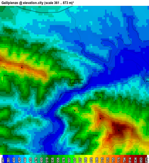
Below is the Elevation map of Gallipienzo, which displays elevation range with different colors. Scale of the first map is from 361 to 873 m (1184 to 2864 ft) with average elevation of 496.2 meters (=1628 ft) [note 1]
These maps also provides idea of topography and contour of this city, they are displayed at different zoom levels. More info about maps, scale and edge coordinates you can find below images.
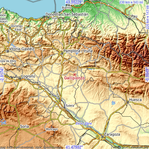
| \ | Map #1 | Topo.Map |
| Scale [m] | 361..873 m | × |
| Scale [ft] | 1184..2864 ft | × |
| Average | 496.2 m = 1628 ft | × |
| Width | 7.2 km = 4.5 mi | 230.5 km = 143.2 mi |
| Height | 7.2 km = 4.5 mi | 230.5 km = 143.2 mi |
| ↑Max Latitude | 42.556879° | 43.55229° |
| Latitude at center | 42.5245° | 42.5245° |
| ↓Min Latitude | 42.492104° | 41.47952° |
| ← Min Longitude | -1.455095° | -2.8174° |
| Longitude center | -1.41115° | -1.41115° |
| →Max Longitude | -1.367205° | -0.0049° |
Nearby cities:
Cities around Gallipienzo sort by population:
• Sangüesa/Zangoza elevation 405 m
11.9 km,  61°
61°
• Carcastillo 354 m
16.4 km,  189°
189°
• Lumbier 468 m
16.7 km,  30°
30°
• Cáseda 425 m
3.7 km,  93°
93°
• Murillo el Fruto 360 m
15.2 km,  195°
195°
• Sos del Rey Católico 634 m
16.4 km,  100°
100°
• San Martín de Unx 613 m
12.3 km,  270°
270°
• Liédena 442 m
15.3 km,  46°
46°
• Ujué 638 m
7.8 km,  249°
249°
• Eslava 556 m
6 km,  318°
318°
• Lerga 618 m
8.8 km,  303°
303°
• Leache 595 m
9.2 km,  1°
1°
Multilingual:
 En español:
Gallipienzo elevación 550 m.
 En France:
Gallipienzo élévation 550 m.
 Auf Deutsch:
Gallipienzo höhe über dem Meeresspiegel ist 550 m.

Sources and notes:
- [note 1] Map square and city borders are not equal. Map elevation data is calculated only from area inside that square.
- [src 1] Elevation data from geonames database provided with same terms of usage.
- [src 2] The elevation map of Gallipienzo is generated using elevation data from NASA's 3 arcsec (90m) resolution SRTM data.
- [src 3] Base (background) map © OpenStreetMap contributors tiles are generated by Geofabrik and OpenTopoMap.
Copyright & License:
This Gallipienzo Elevation Map is licensed under CC BY-SA. You may reuse any part from this page, if you give a proper credit by linking to this URL:
 More info on terms of use page.