Gormaz elevation
Gormaz (Castille and León, Provincia de Soria), Spain elevation is 963 meters and Gormaz elevation in feet is 3159 ft above sea level [src 1]. Gormaz is a seat of a third-order administrative division (feature code) with elevation that is 360 meters (1181 ft) bigger than average city elevation in Spain.
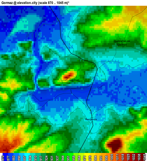
Below is the Elevation map of Gormaz, which displays elevation range with different colors. Scale of the first map is from 870 to 1045 m (2854 to 3428 ft) with average elevation of 918.3 meters (=3013 ft) [note 1]
These maps also provides idea of topography and contour of this city, they are displayed at different zoom levels. More info about maps, scale and edge coordinates you can find below images.
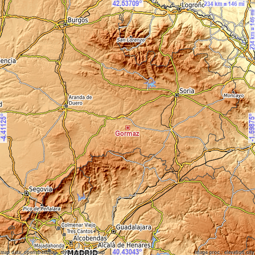
| \ | Map #1 | Topo.Map |
| Scale [m] | 870..1045 m | × |
| Scale [ft] | 2854..3428 ft | × |
| Average | 918.3 m = 3013 ft | × |
| Width | 7.32 km = 4.5 mi | 234.2 km = 145.5 mi |
| Height | 7.32 km = 4.5 mi | 234.2 km = 145.5 mi |
| ↑Max Latitude | 41.525229° | 42.53709° |
| Latitude at center | 41.49232° | 41.49232° |
| ↓Min Latitude | 41.459395° | 40.43043° |
| ← Min Longitude | -3.048945° | -4.41125° |
| Longitude center | -3.005° | -3.005° |
| →Max Longitude | -2.961055° | -1.59875° |
Nearby cities:
Cities around Gormaz sort by population:
• El Burgo de Osma elevation 912 m
11.6 km,  334°
334°
• Berlanga de Duero 937 m
12.3 km,  103°
103°
• Bayubas de Abajo 927 m
9.9 km,  66°
66°
• Quintanas de Gormaz 942 m
3 km,  51°
51°
• Valdenebro 940 m
9.5 km,  21°
21°
• Recuerda 901 m
2.2 km,  156°
156°
• Tajueco 933 m
13.9 km, 69°
• Bayubas de Arriba 961 m
12.2 km, 53°
• Fresno de Caracena 951 m
8.4 km,  238°
238°
• Carrascosa de Abajo 1011 m
10.4 km,  222°
222°
• Villanueva de Gormaz 968 m
5.5 km, 239°
• Caracena 1081 m
14.1 km,  210°
210°
Multilingual:
 En español:
Gormaz elevación 963 m.
 En France:
Gormaz élévation 963 m.


Sources and notes:
- [note 1] Map square and city borders are not equal. Map elevation data is calculated only from area inside that square.
- [src 1] Elevation data from geonames database provided with same terms of usage.
- [src 2] The elevation map of Gormaz is generated using elevation data from NASA's 3 arcsec (90m) resolution SRTM data.
- [src 3] Base (background) map © OpenStreetMap contributors tiles are generated by Geofabrik and OpenTopoMap.
Copyright & License:
This Gormaz Elevation Map is licensed under CC BY-SA. You may reuse any part from this page, if you give a proper credit by linking to this URL:
 More info on terms of use page.