Guitiriz elevation
Guitiriz (Galicia, Provincia de Lugo), Spain elevation is 454 meters and Guitiriz elevation in feet is 1490 ft above sea level [src 1]. Guitiriz is a seat of a third-order administrative division (feature code) with elevation that is 149 meters (489 ft) smaller than average city elevation in Spain.
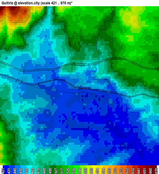
Below is the Elevation map of Guitiriz, which displays elevation range with different colors. Scale of the first map is from 421 to 670 m (1381 to 2198 ft) with average elevation of 476.2 meters (=1562 ft) [note 1]
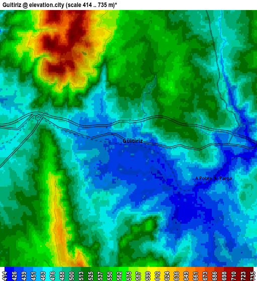
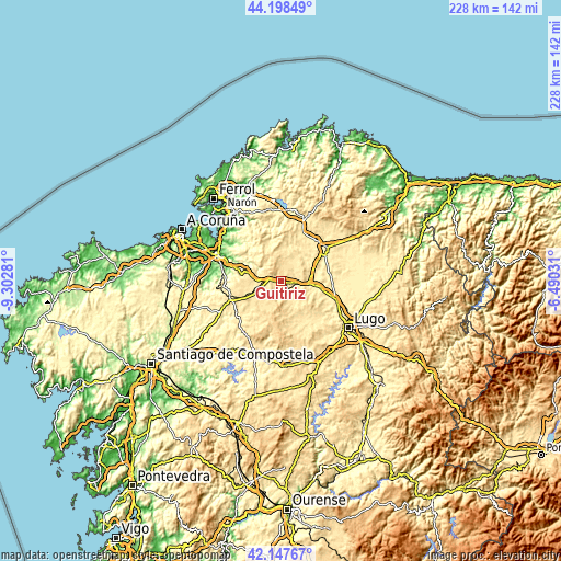
These maps also provides idea of topography and contour of this city, they are displayed at different zoom levels. More info about maps, scale and edge coordinates you can find below images.
| \ | Map #1 | Map #2 | Topo.Map |
| Scale [m] | 421..670 m | 414..735 m | × |
| Scale [ft] | 1381..2198 ft | 1358..2411 ft | × |
| Average | 476.2 m = 1562 ft | 506.1 m = 1660 ft | × |
| Width | 7.13 km = 4.4 mi | 14.25 km = 8.9 mi | 228 km = 141.7 mi |
| Height | 7.13 km = 4.4 mi | 14.25 km = 8.9 mi | 228 km = 141.7 mi |
| ↑Max Latitude | 43.213726° | 43.245745° | 44.19849° |
| Latitude at center | 43.18169° | 43.18169° | 43.18169° |
| ↓Min Latitude | 43.149637° | 43.117568° | 42.14767° |
| ← Min Longitude | -7.940505° | -7.984451° | -9.30281° |
| Longitude center | -7.89656° | -7.89656° | -7.89656° |
| →Max Longitude | -7.852615° | -7.808669° | -6.49031° |
Nearby cities:
Cities around Guitiriz sort by population:
• Vilalba elevation 478 m
21.7 km,  53°
53°
• Outeiro de Rei 413 m
24.5 km,  111°
111°
• Friol 478 m
18.6 km,  153°
153°
• Begonte 397 m
17.4 km,  101°
101°
• Monfero 448 m
19.5 km,  330°
330°
• Sobrado 504 m
19.1 km,  213°
213°
• Aranga 277 m
11.4 km,  301°
301°
• Coirós 220 m
23.2 km,  289°
289°
• Rábade 398 m
23.8 km, 107°
• Vilasantar 435 m
22 km,  236°
236°
• Curtis 534 m
21.4 km,  252°
252°
• Irixoa 364 m
17.5 km,  311°
311°
Multilingual:
 En español:
Guitiriz elevación 454 m.
 En France:
Guitiriz élévation 454 m.
 Auf Deutsch:
Guitiriz höhe über dem Meeresspiegel ist 454 m.

Sources and notes:
- [note 1] Map square and city borders are not equal. Map elevation data is calculated only from area inside that square.
- [src 1] Elevation data from geonames database provided with same terms of usage.
- [src 2] The elevation map of Guitiriz is generated using elevation data from NASA's 3 arcsec (90m) resolution SRTM data.
- [src 3] Base (background) map © OpenStreetMap contributors tiles are generated by Geofabrik and OpenTopoMap.
Copyright & License:
This Guitiriz Elevation Map is licensed under CC BY-SA. You may reuse any part from this page, if you give a proper credit by linking to this URL:
 More info on terms of use page.