Henche elevation
Henche (Castille-La Mancha, Provincia de Guadalajara), Spain elevation is 827 meters and Henche elevation in feet is 2713 ft above sea level [src 1]. Henche is a seat of a third-order administrative division (feature code) with elevation that is 224 meters (735 ft) bigger than average city elevation in Spain.
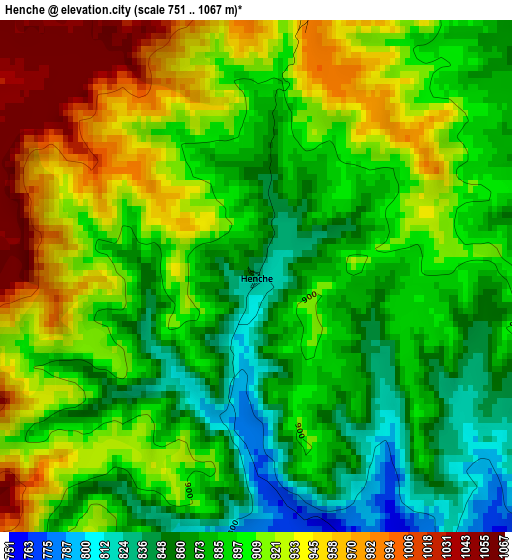
Below is the Elevation map of Henche, which displays elevation range with different colors. Scale of the first map is from 751 to 1067 m (2464 to 3501 ft) with average elevation of 901.9 meters (=2959 ft) [note 1]
These maps also provides idea of topography and contour of this city, they are displayed at different zoom levels. More info about maps, scale and edge coordinates you can find below images.
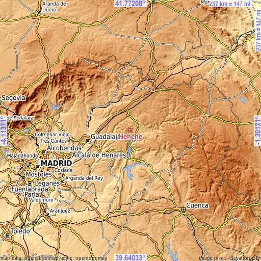
| \ | Map #1 | Topo.Map |
| Scale [m] | 751..1067 m | × |
| Scale [ft] | 2464..3501 ft | × |
| Average | 901.9 m = 2959 ft | × |
| Width | 7.41 km = 4.6 mi | 237 km = 147.3 mi |
| Height | 7.41 km = 4.6 mi | 237 km = 147.3 mi |
| ↑Max Latitude | 40.748041° | 41.77208° |
| Latitude at center | 40.71474° | 40.71474° |
| ↓Min Latitude | 40.681423° | 39.64033° |
| ← Min Longitude | -2.751405° | -4.11371° |
| Longitude center | -2.70746° | -2.70746° |
| →Max Longitude | -2.663515° | -1.30121° |
Nearby cities:
Cities around Henche sort by population:
• Cifuentes elevation 898 m
10.7 km,  42°
42°
• Trillo 730 m
9.8 km,  99°
99°
• Budia 913 m
10.6 km,  203°
203°
• Durón 750 m
10.1 km,  189°
189°
• Chillarón del Rey 807 m
13 km,  173°
173°
• Solanillos del Extremo 999 m
4.1 km,  11°
11°
• Yélamos de Arriba 949 m
14.2 km,  234°
234°
• Masegoso de Tajuña 893 m
12.4 km,  4°
4°
• Mantiel 926 m
11.3 km,  160°
160°
• San Andrés del Rey 1022 m
12.7 km, 228°
• Valderrebollo 877 m
10.8 km,  350°
350°
• Barriopedro 896 m
9.2 km,  335°
335°
Multilingual:
 En español:
Henche elevación 827 m.
 En France:
Henche élévation 827 m.


Sources and notes:
- [note 1] Map square and city borders are not equal. Map elevation data is calculated only from area inside that square.
- [src 1] Elevation data from geonames database provided with same terms of usage.
- [src 2] The elevation map of Henche is generated using elevation data from NASA's 3 arcsec (90m) resolution SRTM data.
- [src 3] Base (background) map © OpenStreetMap contributors tiles are generated by Geofabrik and OpenTopoMap.
Copyright & License:
This Henche Elevation Map is licensed under CC BY-SA. You may reuse any part from this page, if you give a proper credit by linking to this URL:
 More info on terms of use page.