Hiendelaencina elevation
Hiendelaencina (Castille-La Mancha, Provincia de Guadalajara), Spain elevation is 1085 meters and Hiendelaencina elevation in feet is 3560 ft above sea level [src 1]. Hiendelaencina is a seat of a third-order administrative division (feature code) with elevation that is 482 meters (1581 ft) bigger than average city elevation in Spain.
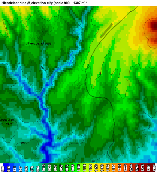
Below is the Elevation map of Hiendelaencina, which displays elevation range with different colors. Scale of the first map is from 900 to 1307 m (2953 to 4288 ft) with average elevation of 1049.6 meters (=3444 ft) [note 1]
These maps also provides idea of topography and contour of this city, they are displayed at different zoom levels. More info about maps, scale and edge coordinates you can find below images.
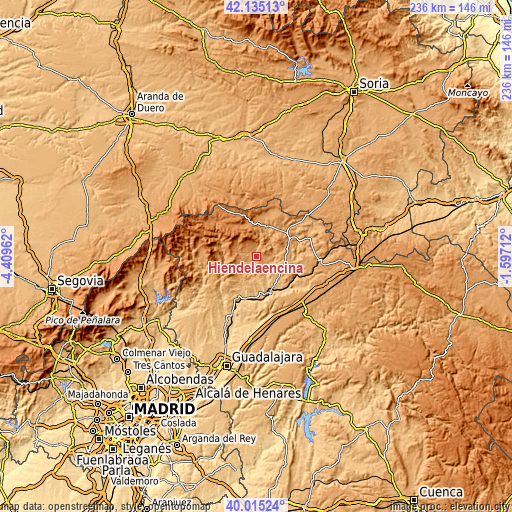
| \ | Map #1 | Topo.Map |
| Scale [m] | 900..1307 m | × |
| Scale [ft] | 2953..4288 ft | × |
| Average | 1049.6 m = 3444 ft | × |
| Width | 7.37 km = 4.6 mi | 235.7 km = 146.5 mi |
| Height | 7.37 km = 4.6 mi | 235.7 km = 146.5 mi |
| ↑Max Latitude | 41.116845° | 42.13513° |
| Latitude at center | 41.08373° | 41.08373° |
| ↓Min Latitude | 41.050598° | 40.01524° |
| ← Min Longitude | -3.047315° | -4.40962° |
| Longitude center | -3.00337° | -3.00337° |
| →Max Longitude | -2.959425° | -1.59712° |
Nearby cities:
Cities around Hiendelaencina sort by population:
• Robledo de Corpes elevation 1148 m
5.9 km,  49°
49°
• Bustares 1255 m
7.7 km,  316°
316°
• Pinilla de Jadraque 838 m
8.7 km,  144°
144°
• San Andrés del Congosto 878 m
9.7 km,  190°
190°
• Pálmaces de Jadraque 918 m
8.4 km,  111°
111°
• Gascueña de Bornova 1205 m
6.7 km,  348°
348°
• Semillas 1201 m
10.1 km,  253°
253°
• Villares de Jadraque 1042 m
2.7 km, 317°
• Zarzuela de Jadraque 1042 m
3.8 km,  243°
243°
• Prádena de Atienza 1167 m
9.9 km,  358°
358°
• Congostrina 1019 m
5.4 km,  164°
164°
• Arroyo de las Fraguas 1215 m
10.8 km,  281°
281°
Multilingual:
 En español:
Hiendelaencina elevación 1085 m.
 En France:
Hiendelaencina élévation 1085 m.
 Auf Deutsch:
Hiendelaencina höhe über dem Meeresspiegel ist 1085 m.

Sources and notes:
- [note 1] Map square and city borders are not equal. Map elevation data is calculated only from area inside that square.
- [src 1] Elevation data from geonames database provided with same terms of usage.
- [src 2] The elevation map of Hiendelaencina is generated using elevation data from NASA's 3 arcsec (90m) resolution SRTM data.
- [src 3] Base (background) map © OpenStreetMap contributors tiles are generated by Geofabrik and OpenTopoMap.
Copyright & License:
This Hiendelaencina Elevation Map is licensed under CC BY-SA. You may reuse any part from this page, if you give a proper credit by linking to this URL:
 More info on terms of use page.