Hombrados elevation
Hombrados (Castille-La Mancha, Provincia de Guadalajara), Spain elevation is 1226 meters and Hombrados elevation in feet is 4022 ft above sea level [src 1]. Hombrados is a seat of a third-order administrative division (feature code) with elevation that is 623 meters (2044 ft) bigger than average city elevation in Spain.
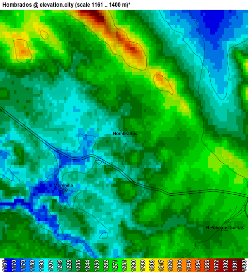
Below is the Elevation map of Hombrados, which displays elevation range with different colors. Scale of the first map is from 1161 to 1400 m (3809 to 4593 ft) with average elevation of 1238.1 meters (=4062 ft) [note 1]
These maps also provides idea of topography and contour of this city, they are displayed at different zoom levels. More info about maps, scale and edge coordinates you can find below images.
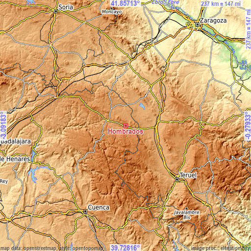
| \ | Map #1 | Topo.Map |
| Scale [m] | 1161..1400 m | × |
| Scale [ft] | 3809..4593 ft | × |
| Average | 1238.1 m = 4062 ft | × |
| Width | 7.4 km = 4.6 mi | 236.7 km = 147.1 mi |
| Height | 7.4 km = 4.6 mi | 236.7 km = 147.1 mi |
| ↑Max Latitude | 40.834437° | 41.85713° |
| Latitude at center | 40.80118° | 40.80118° |
| ↓Min Latitude | 40.767906° | 39.72816° |
| ← Min Longitude | -1.729525° | -3.09183° |
| Longitude center | -1.68558° | -1.68558° |
| →Max Longitude | -1.641635° | -0.27933° |
Nearby cities:
Cities around Hombrados sort by population:
• Odón elevation 1091 m
13.5 km,  47°
47°
• Setiles 1262 m
9.4 km,  142°
142°
• Prados Redondos 1158 m
9.2 km,  258°
258°
• Campillo de Dueñas 1118 m
9.2 km,  0°
0°
• Adobes 1383 m
13.9 km,  177°
177°
• Tordellego 1244 m
8.9 km,  171°
171°
• Morenilla 1194 m
2.4 km,  228°
228°
• Castellar de la Muela 1213 m
6.5 km,  287°
287°
• Torrecuadrada de Molina 1189 m
11.7 km,  240°
240°
• Anquela del Pedregal 1283 m
7.7 km,  213°
213°
• Torremochuela 1169 m
13.8 km,  253°
253°
• Castilnuevo 1085 m
14.6 km,  275°
275°
Multilingual:
 En español:
Hombrados elevación 1226 m.
 En France:
Hombrados élévation 1226 m.
 Auf Deutsch:
Hombrados höhe über dem Meeresspiegel ist 1226 m.

Sources and notes:
- [note 1] Map square and city borders are not equal. Map elevation data is calculated only from area inside that square.
- [src 1] Elevation data from geonames database provided with same terms of usage.
- [src 2] The elevation map of Hombrados is generated using elevation data from NASA's 3 arcsec (90m) resolution SRTM data.
- [src 3] Base (background) map © OpenStreetMap contributors tiles are generated by Geofabrik and OpenTopoMap.
Copyright & License:
This Hombrados Elevation Map is licensed under CC BY-SA. You may reuse any part from this page, if you give a proper credit by linking to this URL:
 More info on terms of use page.