Hontanas elevation
Hontanas (Castille and León, Provincia de Burgos), Spain elevation is 869 meters and Hontanas elevation in feet is 2851 ft above sea level [src 1]. Hontanas is a seat of a third-order administrative division (feature code) with elevation that is 266 meters (873 ft) bigger than average city elevation in Spain.
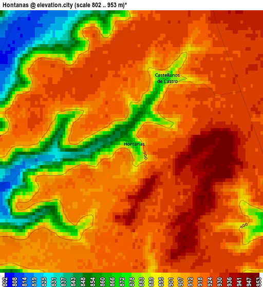
Below is the Elevation map of Hontanas, which displays elevation range with different colors. Scale of the first map is from 802 to 953 m (2631 to 3127 ft) with average elevation of 906.6 meters (=2974 ft) [note 1]
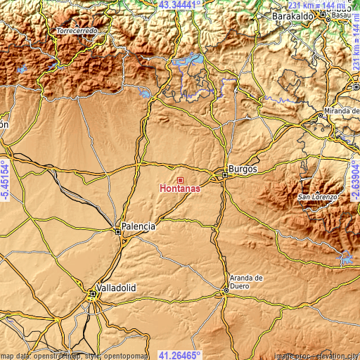
These maps also provides idea of topography and contour of this city, they are displayed at different zoom levels. More info about maps, scale and edge coordinates you can find below images.
| \ | Map #1 | Topo.Map |
| Scale [m] | 802..953 m | × |
| Scale [ft] | 2631..3127 ft | × |
| Average | 906.6 m = 2974 ft | × |
| Width | 7.23 km = 4.5 mi | 231.2 km = 143.7 mi |
| Height | 7.23 km = 4.5 mi | 231.2 km = 143.7 mi |
| ↑Max Latitude | 42.345608° | 43.34441° |
| Latitude at center | 42.31312° | 42.31312° |
| ↓Min Latitude | 42.280615° | 41.26465° |
| ← Min Longitude | -4.089235° | -5.45154° |
| Longitude center | -4.04529° | -4.04529° |
| →Max Longitude | -4.001345° | -2.63904° |
Nearby cities:
Cities around Hontanas sort by population:
• Sasamón elevation 816 m
11.5 km,  0°
0°
• Isar 836 m
10.9 km,  60°
60°
• Villasandino 792 m
8.3 km,  320°
320°
• Villaquirán de los Infantes 813 m
10 km,  162°
162°
• Iglesias 847 m
4.9 km,  109°
109°
• Villanueva de Argaño 839 m
11.8 km,  50°
50°
• Celada del Camino 799 m
10.7 km,  120°
120°
• Hornillos del Camino 824 m
10.2 km,  73°
73°
• Villaldemiro 806 m
8.8 km,  146°
146°
• Castellanos de Castro 872 m
1.9 km,  28°
28°
• Villaquirán de la Puebla 813 m
5.6 km,  233°
233°
• Tamarón 821 m
6.2 km,  134°
134°
Multilingual:
 En español:
Hontanas elevación 869 m.
 En France:
Hontanas élévation 869 m.
 Auf Deutsch:
Hontanas höhe über dem Meeresspiegel ist 869 m.

Sources and notes:
- [note 1] Map square and city borders are not equal. Map elevation data is calculated only from area inside that square.
- [src 1] Elevation data from geonames database provided with same terms of usage.
- [src 2] The elevation map of Hontanas is generated using elevation data from NASA's 3 arcsec (90m) resolution SRTM data.
- [src 3] Base (background) map © OpenStreetMap contributors tiles are generated by Geofabrik and OpenTopoMap.
Copyright & License:
This Hontanas Elevation Map is licensed under CC BY-SA. You may reuse any part from this page, if you give a proper credit by linking to this URL:
 More info on terms of use page.