Hontangas elevation
Hontangas (Castille and León, Provincia de Burgos), Spain elevation is 839 meters and Hontangas elevation in feet is 2753 ft above sea level [src 1]. Hontangas is a seat of a third-order administrative division (feature code) with elevation that is 236 meters (774 ft) bigger than average city elevation in Spain.
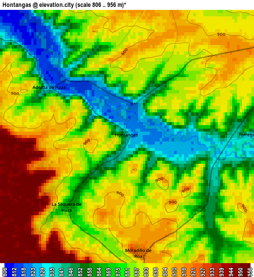
Below is the Elevation map of Hontangas, which displays elevation range with different colors. Scale of the first map is from 806 to 956 m (2644 to 3136 ft) with average elevation of 884.6 meters (=2902 ft) [note 1]
These maps also provides idea of topography and contour of this city, they are displayed at different zoom levels. More info about maps, scale and edge coordinates you can find below images.
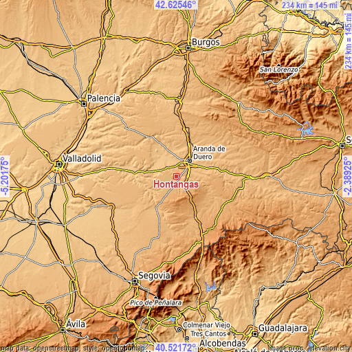
| \ | Map #1 | Topo.Map |
| Scale [m] | 806..956 m | × |
| Scale [ft] | 2644..3136 ft | × |
| Average | 884.6 m = 2902 ft | × |
| Width | 7.31 km = 4.5 mi | 233.9 km = 145.3 mi |
| Height | 7.31 km = 4.5 mi | 233.9 km = 145.3 mi |
| ↑Max Latitude | 41.615023° | 42.62546° |
| Latitude at center | 41.58216° | 41.58216° |
| ↓Min Latitude | 41.54928° | 40.52172° |
| ← Min Longitude | -3.839445° | -5.20175° |
| Longitude center | -3.7955° | -3.7955° |
| →Max Longitude | -3.751555° | -2.38925° |
Nearby cities:
Cities around Hontangas sort by population:
• Castrillo de la Vega elevation 818 m
7.8 km,  8°
8°
• Milagros 850 m
8.1 km,  95°
95°
• Fuentecén 819 m
8 km,  310°
310°
• Adrada de Haza 830 m
2.7 km,  300°
300°
• Moradillo de Roa 921 m
3.4 km,  173°
173°
• Campillo de Aranda 913 m
6.3 km,  60°
60°
• Fuentenebro 922 m
6.9 km,  150°
150°
• Pardilla 883 m
7.8 km,  115°
115°
• Torregalindo 851 m
3.6 km,  88°
88°
• Fuentemolinos 884 m
5.2 km, 298°
• Fuentelisendo 831 m
9.9 km, 297°
• Haza 906 m
4.2 km,  335°
335°
Multilingual:
 En español:
Hontangas elevación 839 m.
 En France:
Hontangas élévation 839 m.
 Auf Deutsch:
Hontangas höhe über dem Meeresspiegel ist 839 m.

Sources and notes:
- [note 1] Map square and city borders are not equal. Map elevation data is calculated only from area inside that square.
- [src 1] Elevation data from geonames database provided with same terms of usage.
- [src 2] The elevation map of Hontangas is generated using elevation data from NASA's 3 arcsec (90m) resolution SRTM data.
- [src 3] Base (background) map © OpenStreetMap contributors tiles are generated by Geofabrik and OpenTopoMap.
Copyright & License:
This Hontangas Elevation Map is licensed under CC BY-SA. You may reuse any part from this page, if you give a proper credit by linking to this URL:
 More info on terms of use page.