Hoyorredondo elevation
Hoyorredondo (Castille and León, Provincia de Ávila), Spain elevation is 1042 meters and Hoyorredondo elevation in feet is 3419 ft above sea level [src 1]. Hoyorredondo is a seat of a third-order administrative division (feature code) with elevation that is 439 meters (1440 ft) bigger than average city elevation in Spain.
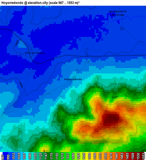
Below is the Elevation map of Hoyorredondo, which displays elevation range with different colors. Scale of the first map is from 967 to 1553 m (3173 to 5095 ft) with average elevation of 1088.4 meters (=3571 ft) [note 1]
These maps also provides idea of topography and contour of this city, they are displayed at different zoom levels. More info about maps, scale and edge coordinates you can find below images.
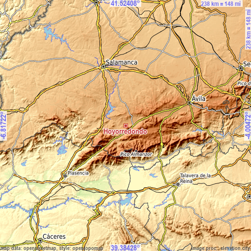
| \ | Map #1 | Topo.Map |
| Scale [m] | 967..1553 m | × |
| Scale [ft] | 3173..5095 ft | × |
| Average | 1088.4 m = 3571 ft | × |
| Width | 7.44 km = 4.6 mi | 237.9 km = 147.8 mi |
| Height | 7.44 km = 4.6 mi | 237.9 km = 147.8 mi |
| ↑Max Latitude | 40.496127° | 41.52408° |
| Latitude at center | 40.4627° | 40.4627° |
| ↓Min Latitude | 40.429257° | 39.38428° |
| ← Min Longitude | -5.454915° | -6.81722° |
| Longitude center | -5.41097° | -5.41097° |
| →Max Longitude | -5.367025° | -4.00472° |
Nearby cities:
Cities around Hoyorredondo sort by population:
• Santa María del Berrocal elevation 1049 m
5.1 km,  5°
5°
• Puente del Congosto 942 m
10.2 km,  287°
287°
• Santiago del Collado 1225 m
5.7 km,  125°
125°
• Malpartida de Corneja 1025 m
8.4 km,  37°
37°
• Aldeanueva de Santa Cruz 1160 m
9 km,  185°
185°
• Navamorales 995 m
5.9 km,  284°
284°
• Santa María de los Caballeros 1042 m
8.8 km,  202°
202°
• San Miguel de Corneja 1063 m
10.9 km,  75°
75°
• Mesegar de Corneja 1022 m
10.3 km,  64°
64°
• San Bartolomé de Corneja 994 m
4 km,  33°
33°
• Villar de Corneja 1001 m
2.3 km,  305°
305°
• Avellaneda 1353 m
8.4 km,  166°
166°
Multilingual:
 En español:
Hoyorredondo elevación 1042 m.
 En France:
Hoyorredondo élévation 1042 m.
 Auf Deutsch:
Hoyorredondo höhe über dem Meeresspiegel ist 1042 m.

Sources and notes:
- [note 1] Map square and city borders are not equal. Map elevation data is calculated only from area inside that square.
- [src 1] Elevation data from geonames database provided with same terms of usage.
- [src 2] The elevation map of Hoyorredondo is generated using elevation data from NASA's 3 arcsec (90m) resolution SRTM data.
- [src 3] Base (background) map © OpenStreetMap contributors tiles are generated by Geofabrik and OpenTopoMap.
Copyright & License:
This Hoyorredondo Elevation Map is licensed under CC BY-SA. You may reuse any part from this page, if you give a proper credit by linking to this URL:
 More info on terms of use page.