Huerta elevation
Huerta (Castille and León, Provincia de Salamanca), Spain elevation is 789 meters and Huerta elevation in feet is 2589 ft above sea level [src 1]. Huerta is a seat of a third-order administrative division (feature code) with elevation that is 186 meters (610 ft) bigger than average city elevation in Spain.
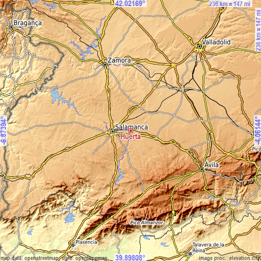
Below is the Elevation map of Huerta, which displays elevation range with different colors. Scale of the first map is from 779 to 918 m (2556 to 3012 ft) with average elevation of 796.4 meters (=2613 ft) [note 1]
These maps also provides idea of topography and contour of this city, they are displayed at different zoom levels. More info about maps, scale and edge coordinates you can find below images.

| \ | Map #1 | Topo.Map |
| Scale [m] | 779..918 m | × |
| Scale [ft] | 2556..3012 ft | × |
| Average | 796.4 m = 2613 ft | × |
| Width | 7.38 km = 4.6 mi | 236.1 km = 146.7 mi |
| Height | 7.38 km = 4.6 mi | 236.1 km = 146.7 mi |
| ↑Max Latitude | 41.001603° | 42.02169° |
| Latitude at center | 40.96843° | 40.96843° |
| ↓Min Latitude | 40.93524° | 39.89808° |
| ← Min Longitude | -5.511635° | -6.87394° |
| Longitude center | -5.46769° | -5.46769° |
| →Max Longitude | -5.423745° | -4.06144° |
Nearby cities:
Cities around Huerta sort by population:
• Villoría elevation 819 m
8.4 km,  69°
69°
• Calvarrasa de Abajo 800 m
7.5 km,  251°
251°
• Babilafuente 800 m
3.7 km, 74°
• Villoruela 828 m
7.6 km,  54°
54°
• Encinas de Abajo 794 m
3.7 km,  183°
183°
• Aldealengua 785 m
7 km,  281°
281°
• Machacón 808 m
6.7 km,  225°
225°
• Aldearrubia 814 m
5.1 km,  329°
329°
• San Morales 795 m
4 km,  313°
313°
• Villagonzalo de Tormes 804 m
8.8 km,  196°
196°
• Cordovilla 825 m
5.4 km,  110°
110°
• Cabezabellosa de la Calzada 855 m
8.6 km,  348°
348°
Multilingual:
 En español:
Huerta elevación 789 m.
 En France:
Huerta élévation 789 m.


Sources and notes:
- [note 1] Map square and city borders are not equal. Map elevation data is calculated only from area inside that square.
- [src 1] Elevation data from geonames database provided with same terms of usage.
- [src 2] The elevation map of Huerta is generated using elevation data from NASA's 3 arcsec (90m) resolution SRTM data.
- [src 3] Base (background) map © OpenStreetMap contributors tiles are generated by Geofabrik and OpenTopoMap.
Copyright & License:
This Huerta Elevation Map is licensed under CC BY-SA. You may reuse any part from this page, if you give a proper credit by linking to this URL:
 More info on terms of use page.