Irueste elevation
Irueste (Castille-La Mancha, Provincia de Guadalajara), Spain elevation is 852 meters and Irueste elevation in feet is 2795 ft above sea level [src 1]. Irueste is a seat of a third-order administrative division (feature code) with elevation that is 249 meters (817 ft) bigger than average city elevation in Spain.
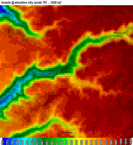
Below is the Elevation map of Irueste, which displays elevation range with different colors. Scale of the first map is from 761 to 1020 m (2497 to 3346 ft) with average elevation of 964.4 meters (=3164 ft) [note 1]
These maps also provides idea of topography and contour of this city, they are displayed at different zoom levels. More info about maps, scale and edge coordinates you can find below images.
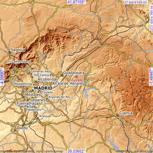
| \ | Map #1 | Topo.Map |
| Scale [m] | 761..1020 m | × |
| Scale [ft] | 2497..3346 ft | × |
| Average | 964.4 m = 3164 ft | × |
| Width | 7.42 km = 4.6 mi | 237.4 km = 147.5 mi |
| Height | 7.42 km = 4.6 mi | 237.4 km = 147.5 mi |
| ↑Max Latitude | 40.645412° | 41.67105° |
| Latitude at center | 40.61206° | 40.61206° |
| ↓Min Latitude | 40.578691° | 39.53602° |
| ← Min Longitude | -2.934665° | -4.29697° |
| Longitude center | -2.89072° | -2.89072° |
| →Max Longitude | -2.846775° | -1.48447° |
Nearby cities:
Cities around Irueste sort by population:
• Tendilla elevation 794 m
9.5 km,  216°
216°
• Alhóndiga 832 m
11 km,  149°
149°
• Fuentelencina 978 m
10.5 km,  176°
176°
• Peñalver 927 m
3.4 km, 177°
• Romanones 756 m
9.6 km,  241°
241°
• Berninches 929 m
8.8 km,  121°
121°
• Yélamos de Arriba 949 m
5.1 km,  52°
52°
• Valdeavellano 969 m
8.9 km,  311°
311°
• Valfermoso de Tajuña 956 m
5.4 km,  278°
278°
• Yélamos de Abajo 943 m
3.5 km, 52°
• San Andrés del Rey 1022 m
6.6 km,  63°
63°
• Atanzón 945 m
10.8 km,  304°
304°
Multilingual:
 En español:
Irueste elevación 852 m.
 En France:
Irueste élévation 852 m.


Sources and notes:
- [note 1] Map square and city borders are not equal. Map elevation data is calculated only from area inside that square.
- [src 1] Elevation data from geonames database provided with same terms of usage.
- [src 2] The elevation map of Irueste is generated using elevation data from NASA's 3 arcsec (90m) resolution SRTM data.
- [src 3] Base (background) map © OpenStreetMap contributors tiles are generated by Geofabrik and OpenTopoMap.
Copyright & License:
This Irueste Elevation Map is licensed under CC BY-SA. You may reuse any part from this page, if you give a proper credit by linking to this URL:
 More info on terms of use page.