Josa elevation
Josa (Aragon, Provincia de Teruel), Spain elevation is 771 meters and Josa elevation in feet is 2530 ft above sea level [src 1]. Josa is a seat of a third-order administrative division (feature code) with elevation that is 168 meters (551 ft) bigger than average city elevation in Spain.
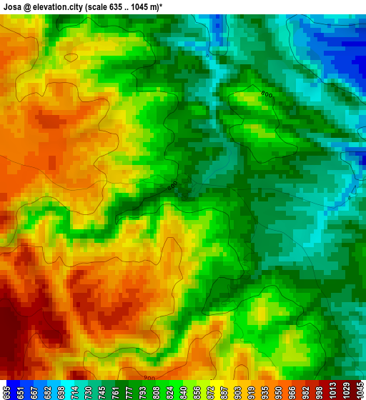
Below is the Elevation map of Josa, which displays elevation range with different colors. Scale of the first map is from 635 to 1045 m (2083 to 3428 ft) with average elevation of 834.3 meters (=2737 ft) [note 1]
These maps also provides idea of topography and contour of this city, they are displayed at different zoom levels. More info about maps, scale and edge coordinates you can find below images.
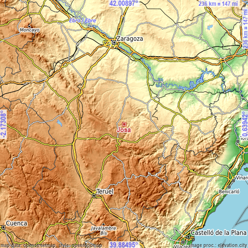
| \ | Map #1 | Topo.Map |
| Scale [m] | 635..1045 m | × |
| Scale [ft] | 2083..3428 ft | × |
| Average | 834.3 m = 2737 ft | × |
| Width | 7.38 km = 4.6 mi | 236.2 km = 146.8 mi |
| Height | 7.38 km = 4.6 mi | 236.2 km = 146.8 mi |
| ↑Max Latitude | 40.98868° | 42.00897° |
| Latitude at center | 40.9555° | 40.9555° |
| ↓Min Latitude | 40.922303° | 39.88495° |
| ← Min Longitude | -0.810775° | -2.17308° |
| Longitude center | -0.76683° | -0.76683° |
| →Max Longitude | -0.722885° | 0.63942° |
Nearby cities:
Cities around Josa sort by population:
• Montalbán elevation 845 m
14 km,  192°
192°
• Muniesa 789 m
9.4 km,  336°
336°
• Oliete 557 m
9.1 km,  58°
58°
• Alacón 636 m
9.7 km,  36°
36°
• Blesa 778 m
14.6 km,  317°
317°
• Huesa del Común 858 m
14.1 km,  295°
295°
• Cortes de Aragón 927 m
6.1 km,  289°
289°
• Obón 701 m
6.8 km,  147°
147°
• Alcaine 664 m
5.1 km,  92°
92°
• Plou 907 m
8.4 km, 299°
• Maicas 971 m
10.5 km,  277°
277°
• Torre de las Arcas 943 m
13.3 km,  161°
161°
Multilingual:
 En español:
Josa elevación 771 m.
 En France:
Josa élévation 771 m.


Sources and notes:
- [note 1] Map square and city borders are not equal. Map elevation data is calculated only from area inside that square.
- [src 1] Elevation data from geonames database provided with same terms of usage.
- [src 2] The elevation map of Josa is generated using elevation data from NASA's 3 arcsec (90m) resolution SRTM data.
- [src 3] Base (background) map © OpenStreetMap contributors tiles are generated by Geofabrik and OpenTopoMap.
Copyright & License:
This Josa Elevation Map is licensed under CC BY-SA. You may reuse any part from this page, if you give a proper credit by linking to this URL:
 More info on terms of use page.