Juneda elevation
Juneda (Catalonia, Província de Lleida), Spain elevation is 267 meters and Juneda elevation in feet is 876 ft above sea level [src 1]. Juneda is a seat of a third-order administrative division (feature code) with elevation that is 336 meters (1102 ft) smaller than average city elevation in Spain.
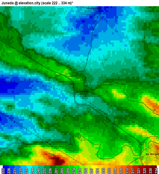
Below is the Elevation map of Juneda, which displays elevation range with different colors. Scale of the first map is from 222 to 334 m (728 to 1096 ft) with average elevation of 255.9 meters (=840 ft) [note 1]
These maps also provides idea of topography and contour of this city, they are displayed at different zoom levels. More info about maps, scale and edge coordinates you can find below images.
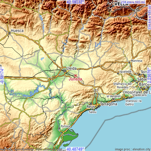
| \ | Map #1 | Topo.Map |
| Scale [m] | 222..334 m | × |
| Scale [ft] | 728..1096 ft | × |
| Average | 255.9 m = 840 ft | × |
| Width | 7.31 km = 4.5 mi | 234 km = 145.4 mi |
| Height | 7.31 km = 4.5 mi | 234 km = 145.4 mi |
| ↑Max Latitude | 41.58135° | 42.59232° |
| Latitude at center | 41.54847° | 41.54847° |
| ↓Min Latitude | 41.515573° | 40.48749° |
| ← Min Longitude | 0.780565° | -0.58174° |
| Longitude center | 0.82451° | 0.82451° |
| →Max Longitude | 0.868455° | 2.23076° |
Nearby cities:
Cities around Juneda sort by population:
• Mollerussa elevation 250 m
11.3 km,  33°
33°
• Bellvís 208 m
13.8 km,  357°
357°
• Arbeca 340 m
8.4 km,  95°
95°
• Alcoletge 217 m
15.5 km,  315°
315°
• Golmés 278 m
13 km,  43°
43°
• Miralcamp 275 m
7.8 km, 36°
• Vilanova de Bellpuig 297 m
13.7 km,  58°
58°
• Castellnou de Seana 274 m
16.5 km,  47°
47°
• Aspa 263 m
14 km,  244°
244°
• el Poal 211 m
15.4 km,  13°
13°
• el Cogul 297 m
14.9 km,  232°
232°
• Sidamon 221 m
9.5 km,  4°
4°
Multilingual:
 En español:
Juneda elevación 267 m.
 En France:
Juneda élévation 267 m.


Sources and notes:
- [note 1] Map square and city borders are not equal. Map elevation data is calculated only from area inside that square.
- [src 1] Elevation data from geonames database provided with same terms of usage.
- [src 2] The elevation map of Juneda is generated using elevation data from NASA's 3 arcsec (90m) resolution SRTM data.
- [src 3] Base (background) map © OpenStreetMap contributors tiles are generated by Geofabrik and OpenTopoMap.
Copyright & License:
This Juneda Elevation Map is licensed under CC BY-SA. You may reuse any part from this page, if you give a proper credit by linking to this URL:
 More info on terms of use page.