La Bañeza elevation
La Bañeza (Castille and León, Provincia de León), Spain elevation is 776 meters and La Bañeza elevation in feet is 2546 ft above sea level [src 1]. La Bañeza is a populated place (feature code) with elevation that is 173 meters (568 ft) bigger than average city elevation in Spain.
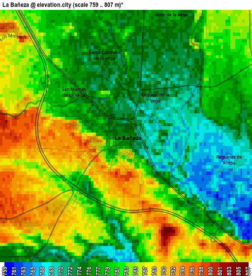
Below is the Elevation map of La Bañeza, which displays elevation range with different colors. Scale of the first map is from 759 to 807 m (2490 to 2648 ft) with average elevation of 780.1 meters (=2559 ft) [note 1]
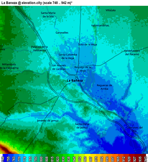
These maps also provides idea of topography and contour of this city, they are displayed at different zoom levels. More info about maps, scale and edge coordinates you can find below images.
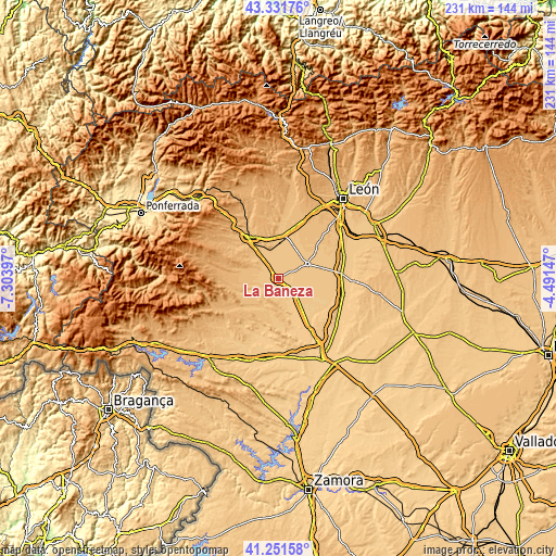
| \ | Map #1 | Map #2 | Topo.Map |
| Scale [m] | 759..807 m | 748..942 m | × |
| Scale [ft] | 2490..2648 ft | 2454..3091 ft | × |
| Average | 780.1 m = 2559 ft | 787.2 m = 2583 ft | × |
| Width | 7.23 km = 4.5 mi | 14.46 km = 9 mi | 231.3 km = 143.7 mi |
| Height | 7.23 km = 4.5 mi | 14.46 km = 9 mi | 231.3 km = 143.7 mi |
| ↑Max Latitude | 42.332755° | 42.365233° | 43.33176° |
| Latitude at center | 42.30026° | 42.30026° | 42.30026° |
| ↓Min Latitude | 42.267748° | 42.23522° | 41.25158° |
| ← Min Longitude | -5.941665° | -5.985611° | -7.30397° |
| Longitude center | -5.89772° | -5.89772° | -5.89772° |
| →Max Longitude | -5.853775° | -5.809829° | -4.49147° |
Nearby cities:
Cities around La Bañeza sort by population:
• Soto de la Vega elevation 778 m
3.8 km,  19°
19°
• Santa Elena de Jamuz 768 m
4.5 km,  169°
169°
• Villamontán de la Valduerna 823 m
8.2 km,  277°
277°
• San Cristóbal de la Polantera 801 m
10.1 km,  355°
355°
• Villazala 801 m
7.6 km,  26°
26°
• Roperuelos del Páramo 772 m
11.8 km,  126°
126°
• Cebrones del Río 759 m
7.6 km, 129°
• Santa María de la Isla 787 m
6.6 km,  337°
337°
• Quintana del Marco 748 m
11.1 km,  159°
159°
• Palacios de la Valduerna 796 m
4.5 km,  312°
312°
• Valdefuentes del Páramo 787 m
6.1 km,  64°
64°
• Regueras de Arriba 769 m
3.2 km,  102°
102°
Multilingual:
 En español:
La Bañeza elevación 776 m.
 En France:
La Bañeza élévation 776 m.
 Auf Deutsch:
La Bañeza höhe über dem Meeresspiegel ist 776 m.

Sources and notes:
- [note 1] Map square and city borders are not equal. Map elevation data is calculated only from area inside that square.
- [src 1] Elevation data from geonames database provided with same terms of usage.
- [src 2] The elevation map of La Bañeza is generated using elevation data from NASA's 3 arcsec (90m) resolution SRTM data.
- [src 3] Base (background) map © OpenStreetMap contributors tiles are generated by Geofabrik and OpenTopoMap.
Copyright & License:
This La Bañeza Elevation Map is licensed under CC BY-SA. You may reuse any part from this page, if you give a proper credit by linking to this URL:
 More info on terms of use page.