Lantadilla elevation
Lantadilla (Castille and León, Provincia de Palencia), Spain elevation is 789 meters and Lantadilla elevation in feet is 2589 ft above sea level [src 1]. Lantadilla is a seat of a third-order administrative division (feature code) with elevation that is 186 meters (610 ft) bigger than average city elevation in Spain.
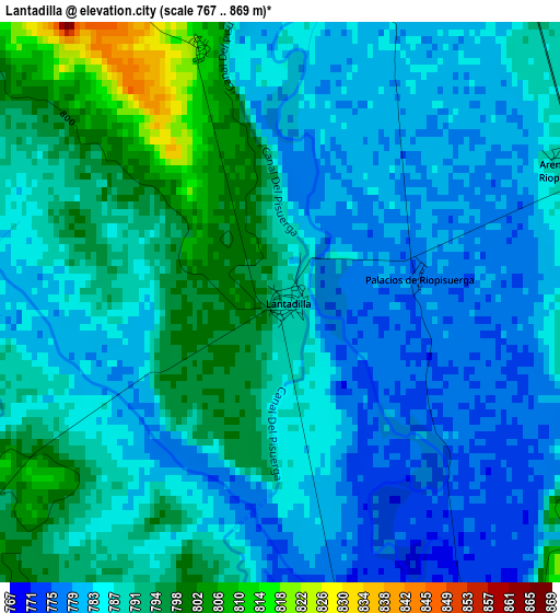
Below is the Elevation map of Lantadilla, which displays elevation range with different colors. Scale of the first map is from 767 to 869 m (2516 to 2851 ft) with average elevation of 787.1 meters (=2582 ft) [note 1]
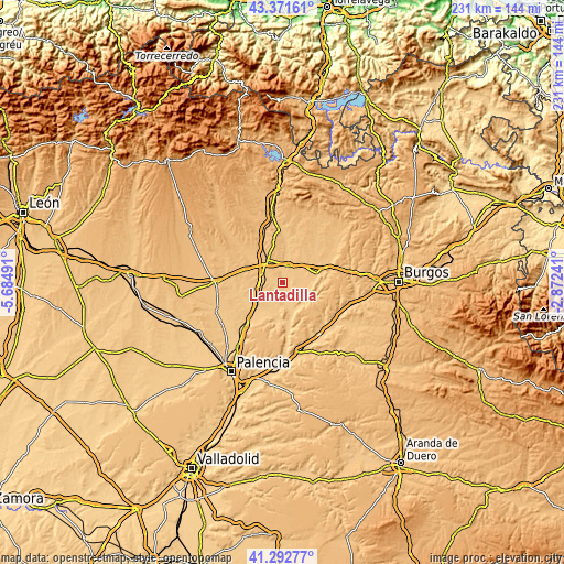
These maps also provides idea of topography and contour of this city, they are displayed at different zoom levels. More info about maps, scale and edge coordinates you can find below images.
| \ | Map #1 | Topo.Map |
| Scale [m] | 767..869 m | × |
| Scale [ft] | 2516..2851 ft | × |
| Average | 787.1 m = 2582 ft | × |
| Width | 7.22 km = 4.5 mi | 231.1 km = 143.6 mi |
| Height | 7.22 km = 4.5 mi | 231.1 km = 143.6 mi |
| ↑Max Latitude | 42.373254° | 43.37161° |
| Latitude at center | 42.34078° | 42.34078° |
| ↓Min Latitude | 42.308289° | 41.29277° |
| ← Min Longitude | -4.322605° | -5.68491° |
| Longitude center | -4.27866° | -4.27866° |
| →Max Longitude | -4.234715° | -2.87241° |
Nearby cities:
Cities around Lantadilla sort by population:
• Melgar de Fernamental elevation 804 m
7.6 km,  21°
21°
• Frómista 781 m
13.3 km,  231°
231°
• Melgar de Yuso 772 m
9.9 km,  168°
168°
• Itero de la Vega 772 m
6.1 km,  162°
162°
• Pedrosa del Príncipe 774 m
12.1 km,  147°
147°
• Boadilla del Camino 783 m
10.6 km,  211°
211°
• Itero del Castillo 776 m
6.3 km, 153°
• Padilla de Arriba 823 m
13 km,  33°
33°
• Padilla de Abajo 799 m
11.2 km,  48°
48°
• Osornillo 814 m
3.5 km,  342°
342°
• Marcilla de Campos 818 m
10 km,  255°
255°
• Requena de Campos 798 m
6.4 km,  235°
235°
Multilingual:
 En español:
Lantadilla elevación 789 m.
 En France:
Lantadilla élévation 789 m.
 Auf Deutsch:
Lantadilla höhe über dem Meeresspiegel ist 789 m.

Sources and notes:
- [note 1] Map square and city borders are not equal. Map elevation data is calculated only from area inside that square.
- [src 1] Elevation data from geonames database provided with same terms of usage.
- [src 2] The elevation map of Lantadilla is generated using elevation data from NASA's 3 arcsec (90m) resolution SRTM data.
- [src 3] Base (background) map © OpenStreetMap contributors tiles are generated by Geofabrik and OpenTopoMap.
Copyright & License:
This Lantadilla Elevation Map is licensed under CC BY-SA. You may reuse any part from this page, if you give a proper credit by linking to this URL:
 More info on terms of use page.