La Pesga elevation
La Pesga (Extremadura, Provincia de Cáceres), Spain elevation is 437 meters and La Pesga elevation in feet is 1434 ft above sea level [src 1]. La Pesga is a populated place (feature code) with elevation that is 166 meters (545 ft) smaller than average city elevation in Spain.
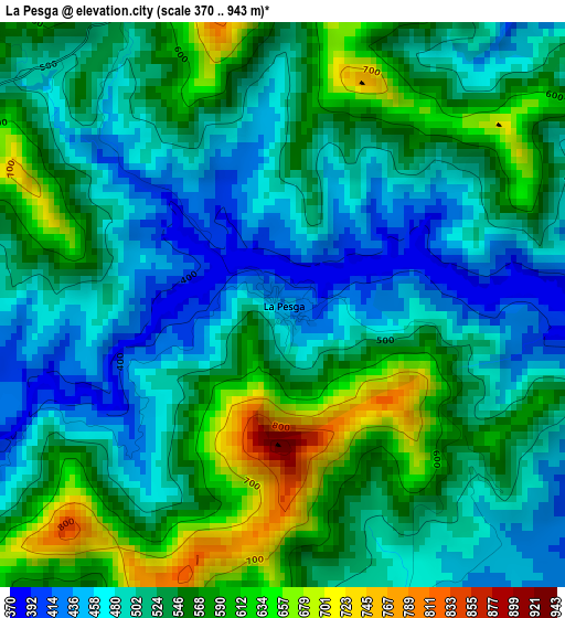
Below is the Elevation map of La Pesga, which displays elevation range with different colors. Scale of the first map is from 370 to 943 m (1214 to 3094 ft) with average elevation of 529.3 meters (=1737 ft) [note 1]
These maps also provides idea of topography and contour of this city, they are displayed at different zoom levels. More info about maps, scale and edge coordinates you can find below images.

| \ | Map #1 | Topo.Map |
| Scale [m] | 370..943 m | × |
| Scale [ft] | 1214..3094 ft | × |
| Average | 529.3 m = 1737 ft | × |
| Width | 7.45 km = 4.6 mi | 238.4 km = 148.1 mi |
| Height | 7.45 km = 4.6 mi | 238.4 km = 148.1 mi |
| ↑Max Latitude | 40.359794° | 41.38985° |
| Latitude at center | 40.3263° | 40.3263° |
| ↓Min Latitude | 40.292789° | 39.24572° |
| ← Min Longitude | -6.219975° | -7.58228° |
| Longitude center | -6.17603° | -6.17603° |
| →Max Longitude | -6.132085° | -4.76978° |
Nearby cities:
Cities around La Pesga sort by population:
• Zarza de Granadilla elevation 394 m
14.7 km,  132°
132°
• Pinofranqueado 466 m
13.4 km,  259°
259°
• Ahigal 390 m
15.2 km,  183°
183°
• Nuñomoral 502 m
10.8 km,  326°
326°
• Casar de Palomero 525 m
7.7 km,  242°
242°
• Caminomorisco 479 m
9.6 km,  270°
270°
• Guijo de Granadilla 392 m
14.8 km, 175°
• Casares de las Hurdes 591 m
15 km,  322°
322°
• Palomero 453 m
12.3 km,  224°
224°
• Herguijuela de la Sierra 657 m
15.8 km,  33°
33°
• Marchagaz 519 m
10.6 km,  232°
232°
• Cerezo 402 m
10.9 km,  203°
203°
Multilingual:
 En español:
La Pesga elevación 437 m.
 En France:
La Pesga élévation 437 m.
 Auf Deutsch:
La Pesga höhe über dem Meeresspiegel ist 437 m.

Sources and notes:
- [note 1] Map square and city borders are not equal. Map elevation data is calculated only from area inside that square.
- [src 1] Elevation data from geonames database provided with same terms of usage.
- [src 2] The elevation map of La Pesga is generated using elevation data from NASA's 3 arcsec (90m) resolution SRTM data.
- [src 3] Base (background) map © OpenStreetMap contributors tiles are generated by Geofabrik and OpenTopoMap.
Copyright & License:
This La Pesga Elevation Map is licensed under CC BY-SA. You may reuse any part from this page, if you give a proper credit by linking to this URL:
 More info on terms of use page.