Lituénigo elevation
Lituénigo (Aragon, Provincia de Zaragoza), Spain elevation is 770 meters and Lituénigo elevation in feet is 2526 ft above sea level [src 1]. Lituénigo is a seat of a third-order administrative division (feature code) with elevation that is 167 meters (548 ft) bigger than average city elevation in Spain.
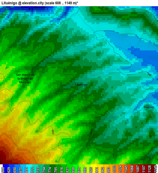
Below is the Elevation map of Lituénigo, which displays elevation range with different colors. Scale of the first map is from 608 to 1149 m (1995 to 3770 ft) with average elevation of 795.2 meters (=2609 ft) [note 1]
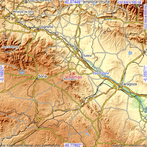
These maps also provides idea of topography and contour of this city, they are displayed at different zoom levels. More info about maps, scale and edge coordinates you can find below images.
| \ | Map #1 | Topo.Map |
| Scale [m] | 608..1149 m | × |
| Scale [ft] | 1995..3770 ft | × |
| Average | 795.2 m = 2609 ft | × |
| Width | 7.28 km = 4.5 mi | 233 km = 144.8 mi |
| Height | 7.28 km = 4.5 mi | 233 km = 144.8 mi |
| ↑Max Latitude | 41.868064° | 42.87449° |
| Latitude at center | 41.83533° | 41.83533° |
| ↓Min Latitude | 41.80258° | 40.77902° |
| ← Min Longitude | -1.805905° | -3.16821° |
| Longitude center | -1.76196° | -1.76196° |
| →Max Longitude | -1.718015° | -0.35571° |
Nearby cities:
Cities around Lituénigo sort by population:
• Tarazona elevation 493 m
8.3 km,  20°
20°
• Vera de Moncayo 633 m
6.3 km,  101°
101°
• Ambel 588 m
13 km,  110°
110°
• Torrellas 574 m
6.6 km,  353°
353°
• Litago 790 m
2.5 km,  162°
162°
• Alcalá de Moncayo 752 m
7.8 km,  134°
134°
• Santa Cruz de Moncayo 621 m
5.3 km,  5°
5°
• Cueva de Ágreda 1298 m
13.2 km,  232°
232°
• Vierlas 456 m
12.2 km,  33°
33°
• Trasmoz 725 m
3.4 km, 107°
• Grisel 630 m
4.9 km,  35°
35°
• Vozmediano 902 m
7.8 km,  271°
271°
Multilingual:
 En español:
Lituénigo elevación 770 m.
 En France:
Lituénigo élévation 770 m.
 Auf Deutsch:
Lituénigo höhe über dem Meeresspiegel ist 770 m.

Sources and notes:
- [note 1] Map square and city borders are not equal. Map elevation data is calculated only from area inside that square.
- [src 1] Elevation data from geonames database provided with same terms of usage.
- [src 2] The elevation map of Lituénigo is generated using elevation data from NASA's 3 arcsec (90m) resolution SRTM data.
- [src 3] Base (background) map © OpenStreetMap contributors tiles are generated by Geofabrik and OpenTopoMap.
Copyright & License:
This Lituénigo Elevation Map is licensed under CC BY-SA. You may reuse any part from this page, if you give a proper credit by linking to this URL:
 More info on terms of use page.