Luelmo elevation
Luelmo (Castille and León, Provincia de Zamora), Spain elevation is 774 meters and Luelmo elevation in feet is 2539 ft above sea level [src 1]. Luelmo is a seat of a third-order administrative division (feature code) with elevation that is 171 meters (561 ft) bigger than average city elevation in Spain.
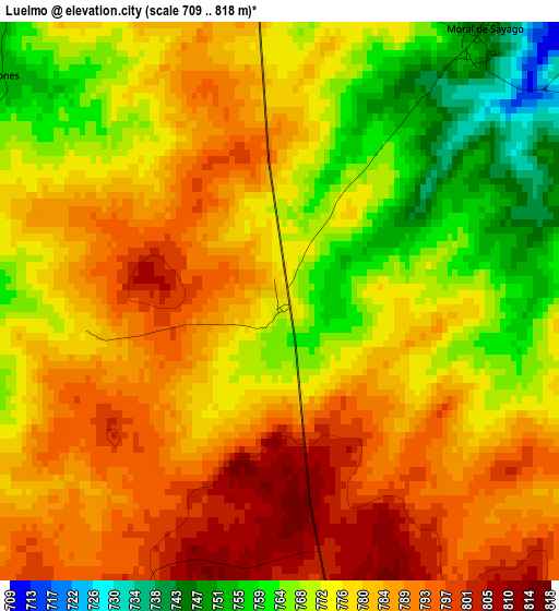
Below is the Elevation map of Luelmo, which displays elevation range with different colors. Scale of the first map is from 709 to 818 m (2326 to 2684 ft) with average elevation of 778.6 meters (=2554 ft) [note 1]
These maps also provides idea of topography and contour of this city, they are displayed at different zoom levels. More info about maps, scale and edge coordinates you can find below images.
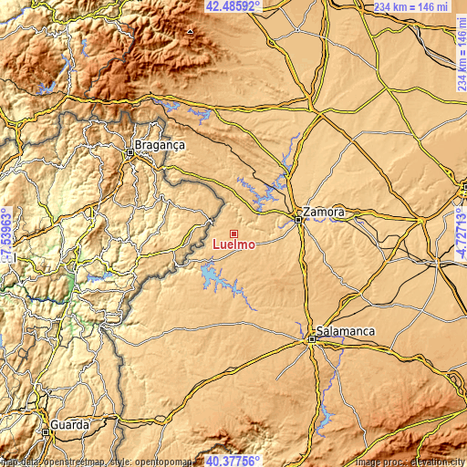
| \ | Map #1 | Topo.Map |
| Scale [m] | 709..818 m | × |
| Scale [ft] | 2326..2684 ft | × |
| Average | 778.6 m = 2554 ft | × |
| Width | 7.33 km = 4.6 mi | 234.4 km = 145.6 mi |
| Height | 7.33 km = 4.6 mi | 234.4 km = 145.6 mi |
| ↑Max Latitude | 41.473235° | 42.48592° |
| Latitude at center | 41.4403° | 41.4403° |
| ↓Min Latitude | 41.407348° | 40.37756° |
| ← Min Longitude | -6.177325° | -7.53963° |
| Longitude center | -6.13338° | -6.13338° |
| →Max Longitude | -6.089435° | -4.72713° |
Nearby cities:
Cities around Luelmo sort by population:
• Bermillo de Sayago elevation 794 m
8.4 km,  167°
167°
• Villar del Buey 772 m
13.1 km,  200°
200°
• Fariza 699 m
11.4 km,  256°
256°
• Villalcampo 783 m
11.6 km,  37°
37°
• Muga de Sayago 782 m
7.9 km,  222°
222°
• Moralina 762 m
5.5 km,  357°
357°
• Moral de Sayago 745 m
4.3 km, 39°
• Torregamones 776 m
6.7 km,  321°
321°
• Villadepera 739 m
11.9 km,  0°
0°
• Villardiegua de la Ribera 763 m
11.4 km,  338°
338°
• Gamones 753 m
4.6 km,  309°
309°
• Argañín 739 m
6.2 km,  269°
269°
Multilingual:
 En español:
Luelmo elevación 774 m.
 En France:
Luelmo élévation 774 m.


Sources and notes:
- [note 1] Map square and city borders are not equal. Map elevation data is calculated only from area inside that square.
- [src 1] Elevation data from geonames database provided with same terms of usage.
- [src 2] The elevation map of Luelmo is generated using elevation data from NASA's 3 arcsec (90m) resolution SRTM data.
- [src 3] Base (background) map © OpenStreetMap contributors tiles are generated by Geofabrik and OpenTopoMap.
Copyright & License:
This Luelmo Elevation Map is licensed under CC BY-SA. You may reuse any part from this page, if you give a proper credit by linking to this URL:
 More info on terms of use page.