Madremanya elevation
Madremanya (Catalonia, Província de Girona), Spain elevation is 132 meters and Madremanya elevation in feet is 433 ft above sea level [src 1]. Madremanya is a seat of a third-order administrative division (feature code) with elevation that is 471 meters (1545 ft) smaller than average city elevation in Spain.
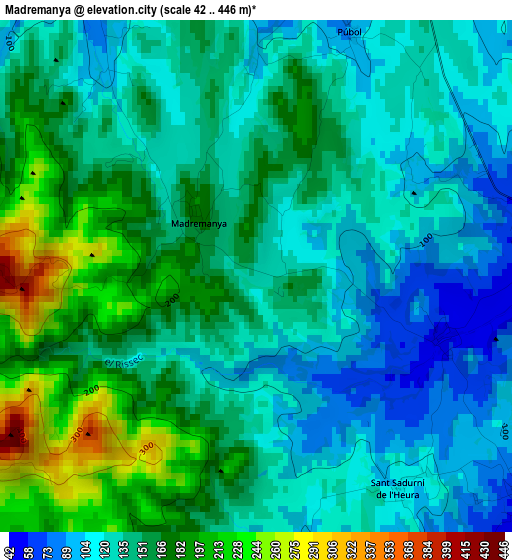
Below is the Elevation map of Madremanya, which displays elevation range with different colors. Scale of the first map is from 42 to 446 m (138 to 1463 ft) with average elevation of 145.5 meters (=477 ft) [note 1]
These maps also provides idea of topography and contour of this city, they are displayed at different zoom levels. More info about maps, scale and edge coordinates you can find below images.
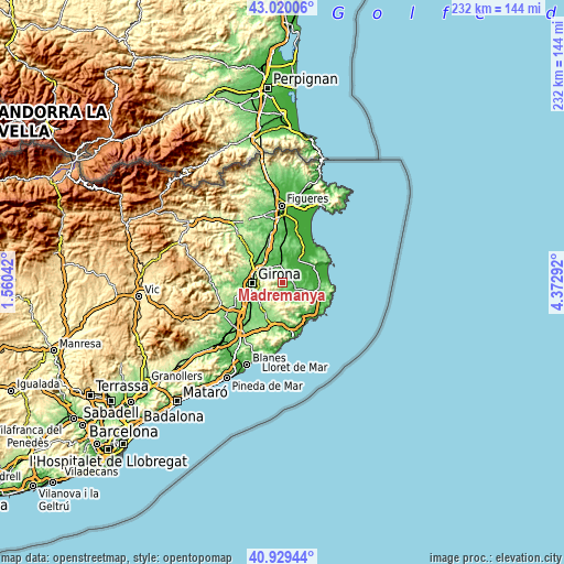
| \ | Map #1 | Topo.Map |
| Scale [m] | 42..446 m | × |
| Scale [ft] | 138..1463 ft | × |
| Average | 145.5 m = 477 ft | × |
| Width | 7.26 km = 4.5 mi | 232.5 km = 144.5 mi |
| Height | 7.26 km = 4.5 mi | 232.4 km = 144.4 mi |
| ↑Max Latitude | 42.015988° | 43.02006° |
| Latitude at center | 41.98333° | 41.98333° |
| ↓Min Latitude | 41.950655° | 40.92944° |
| ← Min Longitude | 2.922725° | 1.56042° |
| Longitude center | 2.96667° | 2.96667° |
| →Max Longitude | 3.010615° | 4.37292° |
Nearby cities:
Cities around Madremanya sort by population:
• la Bisbal d'Empordà elevation 66 m
7.8 km,  118°
118°
• Bordils 45 m
8.1 km,  325°
325°
• Cruïlles 40 m
5.6 km,  131°
131°
• Foixà 65 m
6.5 km,  25°
25°
• Rupià 50 m
5.6 km,  48°
48°
• Ultramort 27 m
8.1 km,  43°
43°
• Ullastret 40 m
8.5 km,  77°
77°
• Sant Joan de Mollet 31 m
7.5 km,  349°
349°
• Parlavà 31 m
6.9 km, 51°
• Juià 134 m
5.6 km,  311°
311°
• Sant Martí Vell 115 m
4.6 km,  323°
323°
• Corçà 40 m
4.1 km,  90°
90°
Multilingual:
 En español:
Madremaña elevación 132 m.
 En France:
Madremanya élévation 132 m.
 Auf Deutsch:
Madremanya höhe über dem Meeresspiegel ist 132 m.

Sources and notes:
- [note 1] Map square and city borders are not equal. Map elevation data is calculated only from area inside that square.
- [src 1] Elevation data from geonames database provided with same terms of usage.
- [src 2] The elevation map of Madremanya is generated using elevation data from NASA's 3 arcsec (90m) resolution SRTM data.
- [src 3] Base (background) map © OpenStreetMap contributors tiles are generated by Geofabrik and OpenTopoMap.
Copyright & License:
This Madremanya Elevation Map is licensed under CC BY-SA. You may reuse any part from this page, if you give a proper credit by linking to this URL:
 More info on terms of use page.