Mataró elevation
Mataró (Catalonia, Província de Barcelona), Spain elevation is 43 meters and Mataró elevation in feet is 141 ft above sea level [src 1]. Mataró is a seat of a third-order administrative division (feature code) with elevation that is 560 meters (1837 ft) smaller than average city elevation in Spain.
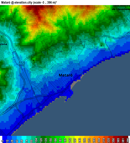
Below is the Elevation map of Mataró, which displays elevation range with different colors. Scale of the first map is from -3 to 396 m (-10 to 1299 ft) with average elevation of 106 meters (=348 ft) [note 1]
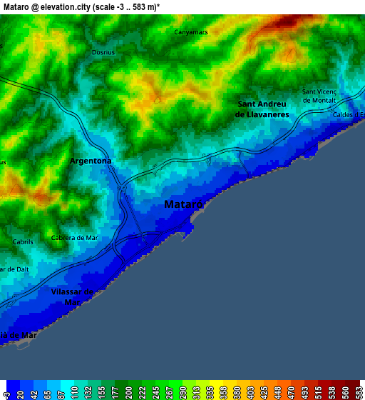
These maps also provides idea of topography and contour of this city, they are displayed at different zoom levels. More info about maps, scale and edge coordinates you can find below images.
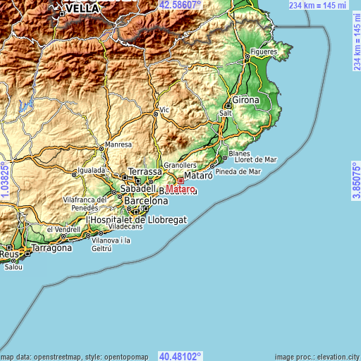
| \ | Map #1 | Map #2 | Topo.Map |
| Scale [m] | -3..396 m | -3..583 m | × |
| Scale [ft] | -10..1299 ft | -10..1913 ft | × |
| Average | 106 m = 348 ft | 179.9 m = 590 ft | × |
| Width | 7.31 km = 4.5 mi | 14.63 km = 9.1 mi | 234.1 km = 145.5 mi |
| Height | 7.31 km = 4.5 mi | 14.63 km = 9.1 mi | 234.1 km = 145.5 mi |
| ↑Max Latitude | 41.574993° | 41.60786° | 42.58607° |
| Latitude at center | 41.54211° | 41.54211° | 41.54211° |
| ↓Min Latitude | 41.50921° | 41.476293° | 40.48102° |
| ← Min Longitude | 2.400555° | 2.356609° | 1.03825° |
| Longitude center | 2.4445° | 2.4445° | 2.4445° |
| →Max Longitude | 2.488445° | 2.532391° | 3.85075° |
Nearby cities:
Cities around Mataró sort by population:
• Premià de Mar elevation 6 m
8.6 km,  229°
229°
• Vilassar de Mar 19 m
6 km, 226°
• Arenys de Mar 25 m
9.8 km,  63°
63°
• Argentona 85 m
3.8 km,  289°
289°
• La Roca del Vallès 198 m
10.3 km,  296°
296°
• Sant Andreu de Llavaneres 107 m
4.2 km,  49°
49°
• Cabrils 179 m
6.4 km,  255°
255°
• Sant Vicenç de Montalt 144 m
6.7 km, 52°
• Cabrera de Mar 32 m
4.7 km, 232°
• Dosrius 323 m
5.1 km,  333°
333°
• Òrrius 281 m
7.9 km,  276°
276°
• Caldes d'Estrac 1 m
7.9 km,  69°
69°
Multilingual:
 En español:
Mataró elevación 43 m.
 En France:
Mataró élévation 43 m.


Sources and notes:
- [note 1] Map square and city borders are not equal. Map elevation data is calculated only from area inside that square.
- [src 1] Elevation data from geonames database provided with same terms of usage.
- [src 2] The elevation map of Mataró is generated using elevation data from NASA's 3 arcsec (90m) resolution SRTM data.
- [src 3] Base (background) map © OpenStreetMap contributors tiles are generated by Geofabrik and OpenTopoMap.
Copyright & License:
This Mataró Elevation Map is licensed under CC BY-SA. You may reuse any part from this page, if you give a proper credit by linking to this URL:
 More info on terms of use page.