Mengamuñoz elevation
Mengamuñoz (Castille and León, Provincia de Ávila), Spain elevation is 1318 meters and Mengamuñoz elevation in feet is 4324 ft above sea level [src 1]. Mengamuñoz is a seat of a third-order administrative division (feature code) with elevation that is 715 meters (2346 ft) bigger than average city elevation in Spain.
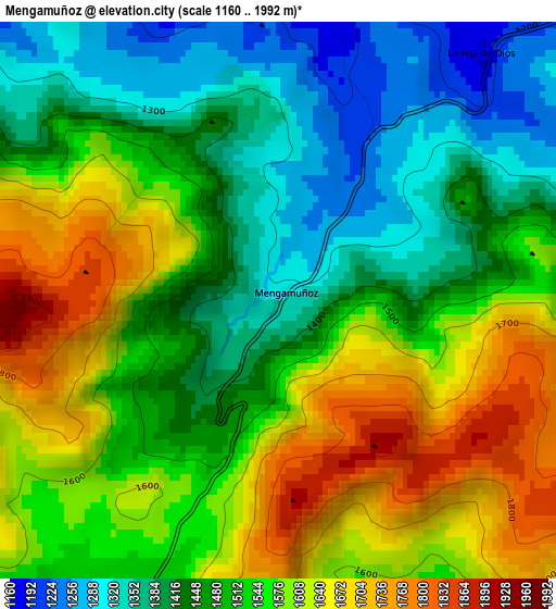
Below is the Elevation map of Mengamuñoz, which displays elevation range with different colors. Scale of the first map is from 1160 to 1992 m (3806 to 6535 ft) with average elevation of 1518.7 meters (=4983 ft) [note 1]
These maps also provides idea of topography and contour of this city, they are displayed at different zoom levels. More info about maps, scale and edge coordinates you can find below images.
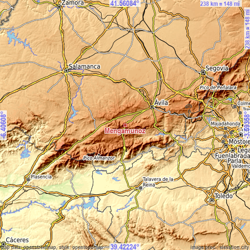
| \ | Map #1 | Topo.Map |
| Scale [m] | 1160..1992 m | × |
| Scale [ft] | 3806..6535 ft | × |
| Average | 1518.7 m = 4983 ft | × |
| Width | 7.43 km = 4.6 mi | 237.8 km = 147.8 mi |
| Height | 7.43 km = 4.6 mi | 237.8 km = 147.8 mi |
| ↑Max Latitude | 40.533468° | 41.56084° |
| Latitude at center | 40.50006° | 40.50006° |
| ↓Min Latitude | 40.466635° | 39.42224° |
| ← Min Longitude | -5.043775° | -6.40608° |
| Longitude center | -4.99983° | -4.99983° |
| →Max Longitude | -4.955885° | -3.59358° |
Nearby cities:
Cities around Mengamuñoz sort by population:
• Solosancho elevation 1126 m
10 km,  53°
53°
• Muñana 1172 m
10.1 km,  352°
352°
• Navalacruz 1236 m
8.9 km,  139°
139°
• Pradosegar 1171 m
8.1 km,  313°
313°
• Amavida 1176 m
9.9 km,  325°
325°
• Cepeda la Mora 1497 m
6.2 km,  221°
221°
• Muñotello 1156 m
5.9 km,  322°
322°
• Poveda 1194 m
10.1 km, 318°
• Navadijos 1515 m
10.9 km, 220°
• Garganta del Villar 1470 m
10.5 km,  237°
237°
• Navaquesera 1528 m
11.2 km, 137°
• Narros del Puerto 1152 m
4.6 km,  7°
7°
Multilingual:
 En español:
Mengamuñoz elevación 1318 m.
 En France:
Mengamuñoz élévation 1318 m.
 Auf Deutsch:
Mengamuñoz höhe über dem Meeresspiegel ist 1318 m.

Sources and notes:
- [note 1] Map square and city borders are not equal. Map elevation data is calculated only from area inside that square.
- [src 1] Elevation data from geonames database provided with same terms of usage.
- [src 2] The elevation map of Mengamuñoz is generated using elevation data from NASA's 3 arcsec (90m) resolution SRTM data.
- [src 3] Base (background) map © OpenStreetMap contributors tiles are generated by Geofabrik and OpenTopoMap.
Copyright & License:
This Mengamuñoz Elevation Map is licensed under CC BY-SA. You may reuse any part from this page, if you give a proper credit by linking to this URL:
 More info on terms of use page.