Miranda de Azán elevation
Miranda de Azán (Castille and León, Provincia de Salamanca), Spain elevation is 821 meters and Miranda de Azán elevation in feet is 2694 ft above sea level [src 1]. Miranda de Azán is a seat of a third-order administrative division (feature code) with elevation that is 218 meters (715 ft) bigger than average city elevation in Spain.
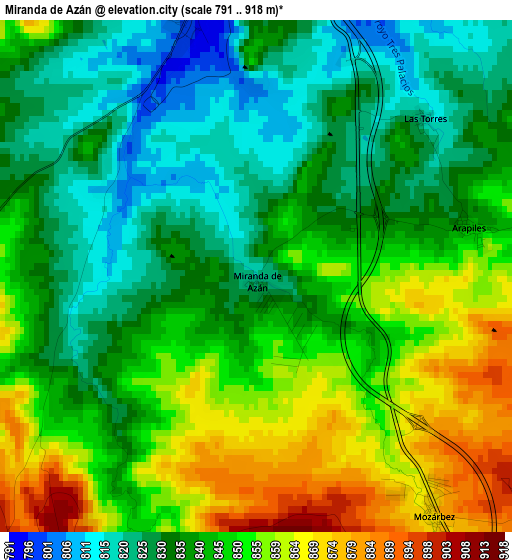
Below is the Elevation map of Miranda de Azán, which displays elevation range with different colors. Scale of the first map is from 791 to 918 m (2595 to 3012 ft) with average elevation of 842.7 meters (=2765 ft) [note 1]
These maps also provides idea of topography and contour of this city, they are displayed at different zoom levels. More info about maps, scale and edge coordinates you can find below images.
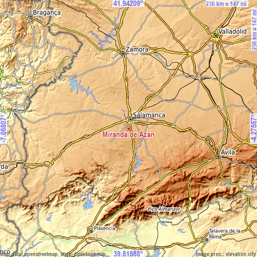
| \ | Map #1 | Topo.Map |
| Scale [m] | 791..918 m | × |
| Scale [ft] | 2595..3012 ft | × |
| Average | 842.7 m = 2765 ft | × |
| Width | 7.39 km = 4.6 mi | 236.4 km = 146.9 mi |
| Height | 7.39 km = 4.6 mi | 236.4 km = 146.9 mi |
| ↑Max Latitude | 40.920734° | 41.94209° |
| Latitude at center | 40.88752° | 40.88752° |
| ↓Min Latitude | 40.854289° | 39.81588° |
| ← Min Longitude | -5.725765° | -7.08807° |
| Longitude center | -5.68182° | -5.68182° |
| →Max Longitude | -5.637875° | -4.27557° |
Nearby cities:
Cities around Miranda de Azán sort by population:
• Salamanca elevation 815 m
9.2 km,  9°
9°
• Santa Marta de Tormes 788 m
8.4 km,  33°
33°
• Carbajosa de la Sagrada 794 m
5.7 km, 27°
• Pelabravo 816 m
10.2 km,  57°
57°
• Aldeatejada 795 m
3.9 km,  346°
346°
• Doñinos de Salamanca 830 m
9.6 km,  327°
327°
• Calvarrasa de Arriba 849 m
7.8 km,  74°
74°
• Arapiles 843 m
3.2 km,  77°
77°
• Mozárbez 877 m
4.3 km,  143°
143°
• Morille 931 m
9.1 km,  188°
188°
• Martinamor 957 m
11.4 km, 142°
• Valdemierque 941 m
11.1 km,  131°
131°
Multilingual:
 En español:
Miranda de Azán elevación 821 m.
 En France:
Miranda de Azán élévation 821 m.
 Auf Deutsch:
Miranda de Azán höhe über dem Meeresspiegel ist 821 m.

Sources and notes:
- [note 1] Map square and city borders are not equal. Map elevation data is calculated only from area inside that square.
- [src 1] Elevation data from geonames database provided with same terms of usage.
- [src 2] The elevation map of Miranda de Azán is generated using elevation data from NASA's 3 arcsec (90m) resolution SRTM data.
- [src 3] Base (background) map © OpenStreetMap contributors tiles are generated by Geofabrik and OpenTopoMap.
Copyright & License:
This Miranda de Azán Elevation Map is licensed under CC BY-SA. You may reuse any part from this page, if you give a proper credit by linking to this URL:
 More info on terms of use page.