Mogarraz elevation
Mogarraz (Castille and León, Provincia de Salamanca), Spain elevation is 786 meters and Mogarraz elevation in feet is 2579 ft above sea level [src 1]. Mogarraz is a seat of a third-order administrative division (feature code) with elevation that is 183 meters (600 ft) bigger than average city elevation in Spain.
Below is the Elevation map of Mogarraz, which displays elevation range with different colors. Scale of the first map is from 455 to 1374 m (1493 to 4508 ft) with average elevation of 818.9 meters (=2687 ft) [note 1]
These maps also provides idea of topography and contour of this city, they are displayed at different zoom levels. More info about maps, scale and edge coordinates you can find below images.
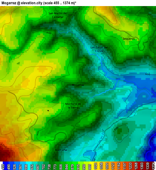
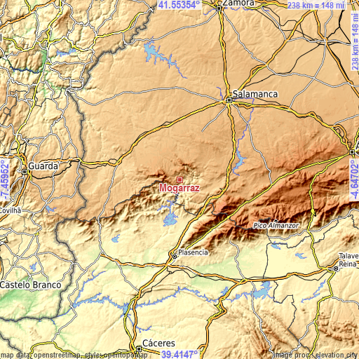
| \ | Map #1 | Topo.Map |
| Scale [m] | 455..1374 m | × |
| Scale [ft] | 1493..4508 ft | × |
| Average | 818.9 m = 2687 ft | × |
| Width | 7.43 km = 4.6 mi | 237.8 km = 147.8 mi |
| Height | 7.43 km = 4.6 mi | 237.8 km = 147.8 mi |
| ↑Max Latitude | 40.526052° | 41.55354° |
| Latitude at center | 40.49264° | 40.49264° |
| ↓Min Latitude | 40.459212° | 39.4147° |
| ← Min Longitude | -6.097215° | -7.45952° |
| Longitude center | -6.05327° | -6.05327° |
| →Max Longitude | -6.009325° | -4.64702° |
Nearby cities:
Cities around Mogarraz sort by population:
• La Alberca elevation 1053 m
4.9 km,  265°
265°
• Sotoserrano 512 m
6.6 km,  164°
164°
• Miranda del Castañar 649 m
4.9 km,  100°
100°
• Cepeda 628 m
3.1 km, 160°
• Herguijuela de la Sierra 657 m
5.6 km,  198°
198°
• San Martín del Castañar 838 m
3.5 km,  344°
344°
• Sequeros 939 m
3.3 km,  46°
46°
• Garcibuey 700 m
5.6 km,  62°
62°
• Villanueva del Conde 800 m
4 km, 60°
• Madroñal 679 m
3.3 km,  194°
194°
• Nava de Francia 1042 m
7.2 km,  311°
311°
• Monforte de la Sierra 823 m
1.1 km, 194°
Multilingual:
 En español:
Mogarraz elevación 786 m.
 En France:
Mogarraz élévation 786 m.
 Auf Deutsch:
Mogarraz höhe über dem Meeresspiegel ist 786 m.

Sources and notes:
- [note 1] Map square and city borders are not equal. Map elevation data is calculated only from area inside that square.
- [src 1] Elevation data from geonames database provided with same terms of usage.
- [src 2] The elevation map of Mogarraz is generated using elevation data from NASA's 3 arcsec (90m) resolution SRTM data.
- [src 3] Base (background) map © OpenStreetMap contributors tiles are generated by Geofabrik and OpenTopoMap.
Copyright & License:
This Mogarraz Elevation Map is licensed under CC BY-SA. You may reuse any part from this page, if you give a proper credit by linking to this URL:
 More info on terms of use page.