Montamarta elevation
Montamarta (Castille and León, Provincia de Zamora), Spain elevation is 694 meters and Montamarta elevation in feet is 2277 ft above sea level [src 1]. Montamarta is a seat of a third-order administrative division (feature code) with elevation that is 91 meters (299 ft) bigger than average city elevation in Spain.
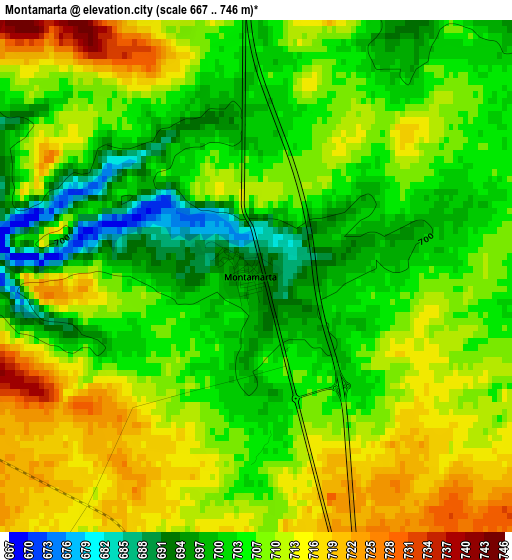
Below is the Elevation map of Montamarta, which displays elevation range with different colors. Scale of the first map is from 667 to 746 m (2188 to 2448 ft) with average elevation of 707 meters (=2320 ft) [note 1]
These maps also provides idea of topography and contour of this city, they are displayed at different zoom levels. More info about maps, scale and edge coordinates you can find below images.
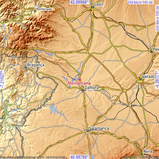
| \ | Map #1 | Topo.Map |
| Scale [m] | 667..746 m | × |
| Scale [ft] | 2188..2448 ft | × |
| Average | 707 m = 2320 ft | × |
| Width | 7.3 km = 4.5 mi | 233.7 km = 145.2 mi |
| Height | 7.3 km = 4.5 mi | 233.7 km = 145.2 mi |
| ↑Max Latitude | 41.68007° | 42.68948° |
| Latitude at center | 41.64724° | 41.64724° |
| ↓Min Latitude | 41.614393° | 40.58786° |
| ← Min Longitude | -5.847965° | -7.21027° |
| Longitude center | -5.80402° | -5.80402° |
| →Max Longitude | -5.760075° | -4.39777° |
Nearby cities:
Cities around Montamarta sort by population:
• Torres del Carrizal elevation 648 m
11.5 km,  107°
107°
• Pajares de la Lampreana 695 m
11.9 km,  50°
50°
• Moreruela de los Infanzones 671 m
8.3 km,  102°
102°
• Cubillos 670 m
9.7 km,  146°
146°
• Valcabado 682 m
11.9 km,  157°
157°
• San Cebrián de Castro 688 m
7.7 km,  31°
31°
• Santa Eufemia del Barco 723 m
8.6 km,  293°
293°
• Palacios del Pan 718 m
7.9 km,  230°
230°
• Perilla de Castro 726 m
10.6 km,  325°
325°
• Manzanal del Barco 704 m
11.9 km,  263°
263°
• Piedrahita de Castro 701 m
7.3 km,  59°
59°
• Roales 700 m
10.9 km,  165°
165°
Multilingual:
 En español:
Montamarta elevación 694 m.
 En France:
Montamarta élévation 694 m.
 Auf Deutsch:
Montamarta höhe über dem Meeresspiegel ist 694 m.

Sources and notes:
- [note 1] Map square and city borders are not equal. Map elevation data is calculated only from area inside that square.
- [src 1] Elevation data from geonames database provided with same terms of usage.
- [src 2] The elevation map of Montamarta is generated using elevation data from NASA's 3 arcsec (90m) resolution SRTM data.
- [src 3] Base (background) map © OpenStreetMap contributors tiles are generated by Geofabrik and OpenTopoMap.
Copyright & License:
This Montamarta Elevation Map is licensed under CC BY-SA. You may reuse any part from this page, if you give a proper credit by linking to this URL:
 More info on terms of use page.