Muiños elevation
Muiños (Galicia, Provincia de Ourense), Spain elevation is 625 meters and Muiños elevation in feet is 2051 ft above sea level [src 1]. Muiños is a populated place (feature code) with elevation that is 22 meters (72 ft) bigger than average city elevation in Spain.
Below is the Elevation map of Muiños, which displays elevation range with different colors. Scale of the first map is from 539 to 982 m (1768 to 3222 ft) with average elevation of 699.2 meters (=2294 ft) [note 1]
These maps also provides idea of topography and contour of this city, they are displayed at different zoom levels. More info about maps, scale and edge coordinates you can find below images.
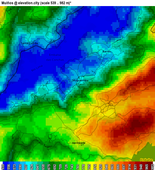
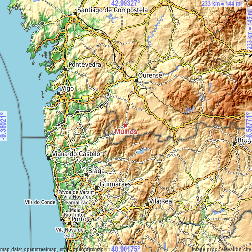
| \ | Map #1 | Topo.Map |
| Scale [m] | 539..982 m | × |
| Scale [ft] | 1768..3222 ft | × |
| Average | 699.2 m = 2294 ft | × |
| Width | 7.27 km = 4.5 mi | 232.6 km = 144.5 mi |
| Height | 7.27 km = 4.5 mi | 232.5 km = 144.5 mi |
| ↑Max Latitude | 41.988762° | 42.99327° |
| Latitude at center | 41.95609° | 41.95609° |
| ↓Min Latitude | 41.923401° | 40.90175° |
| ← Min Longitude | -8.017905° | -9.38021° |
| Longitude center | -7.97396° | -7.97396° |
| →Max Longitude | -7.930015° | -6.56771° |
Nearby cities:
Cities around Muiños sort by population:
• Xinzo de Limia elevation 625 m
23.8 km,  59°
59°
• Celanova 515 m
22 km,  4°
4°
• Bande 728 m
8.4 km,  359°
359°
• Rairiz de Veiga 621 m
18.2 km,  38°
38°
• Verea 806 m
16.9 km,  352°
352°
• Entrimo 502 m
12.1 km,  257°
257°
• Calvos 901 m
6.5 km,  98°
98°
• Baltar 822 m
21.4 km,  91°
91°
• Blancos 804 m
18.9 km,  76°
76°
• Quintela de Leirado 376 m
23 km,  332°
332°
• Lobios 582 m
13 km,  226°
226°
• Porqueira 636 m
12.3 km, 56°
Multilingual:
 En español:
Muiños elevación 625 m.
 En France:
Muiños élévation 625 m.


Sources and notes:
- [note 1] Map square and city borders are not equal. Map elevation data is calculated only from area inside that square.
- [src 1] Elevation data from geonames database provided with same terms of usage.
- [src 2] The elevation map of Muiños is generated using elevation data from NASA's 3 arcsec (90m) resolution SRTM data.
- [src 3] Base (background) map © OpenStreetMap contributors tiles are generated by Geofabrik and OpenTopoMap.
Copyright & License:
This Muiños Elevation Map is licensed under CC BY-SA. You may reuse any part from this page, if you give a proper credit by linking to this URL:
 More info on terms of use page.