Navacerrada elevation
Navacerrada (Madrid, Provincia de Madrid), Spain elevation is 1199 meters and Navacerrada elevation in feet is 3934 ft above sea level [src 1]. Navacerrada is a seat of a third-order administrative division (feature code) with elevation that is 596 meters (1955 ft) bigger than average city elevation in Spain.
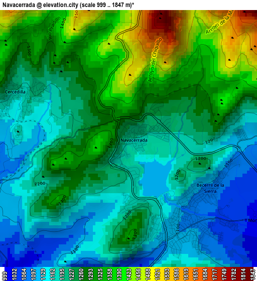
Below is the Elevation map of Navacerrada, which displays elevation range with different colors. Scale of the first map is from 999 to 1847 m (3278 to 6060 ft) with average elevation of 1247.3 meters (=4092 ft) [note 1]
These maps also provides idea of topography and contour of this city, they are displayed at different zoom levels. More info about maps, scale and edge coordinates you can find below images.
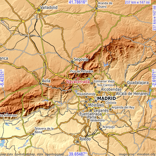
| \ | Map #1 | Topo.Map |
| Scale [m] | 999..1847 m | × |
| Scale [ft] | 3278..6060 ft | × |
| Average | 1247.3 m = 4092 ft | × |
| Width | 7.41 km = 4.6 mi | 237 km = 147.3 mi |
| Height | 7.41 km = 4.6 mi | 237 km = 147.3 mi |
| ↑Max Latitude | 40.762344° | 41.78616° |
| Latitude at center | 40.72905° | 40.72905° |
| ↓Min Latitude | 40.69574° | 39.65487° |
| ← Min Longitude | -4.060905° | -5.42321° |
| Longitude center | -4.01696° | -4.01696° |
| →Max Longitude | -3.973015° | -2.61071° |
Nearby cities:
Cities around Navacerrada sort by population:
• Collado-Villalba elevation 884 m
10.5 km,  174°
174°
• Guadarrama 966 m
8.8 km,  224°
224°
• Alpedrete 919 m
7.8 km,  185°
185°
• Moralzarzal 975 m
6.9 km,  145°
145°
• Hoyo de Manzanares 1005 m
15 km,  141°
141°
• Cercedilla 1194 m
3.6 km,  291°
291°
• Manzanares el Real 911 m
13 km,  91°
91°
• Collado Mediano 1020 m
4 km, 187°
• Boalo 928 m
8.6 km,  99°
99°
• Becerril de la Sierra 1085 m
2.7 km,  119°
119°
• Los Molinos 1053 m
5 km,  252°
252°
• Navalquejigo 889 m
13.8 km, 191°
Multilingual:
 En español:
Navacerrada elevación 1199 m.
 En France:
Navacerrada élévation 1199 m.
 Auf Deutsch:
Navacerrada höhe über dem Meeresspiegel ist 1199 m.

Sources and notes:
- [note 1] Map square and city borders are not equal. Map elevation data is calculated only from area inside that square.
- [src 1] Elevation data from geonames database provided with same terms of usage.
- [src 2] The elevation map of Navacerrada is generated using elevation data from NASA's 3 arcsec (90m) resolution SRTM data.
- [src 3] Base (background) map © OpenStreetMap contributors tiles are generated by Geofabrik and OpenTopoMap.
Copyright & License:
This Navacerrada Elevation Map is licensed under CC BY-SA. You may reuse any part from this page, if you give a proper credit by linking to this URL:
 More info on terms of use page.