Navaleno elevation
Navaleno (Castille and León, Provincia de Soria), Spain elevation is 1116 meters and Navaleno elevation in feet is 3661 ft above sea level [src 1]. Navaleno is a seat of a third-order administrative division (feature code) with elevation that is 513 meters (1683 ft) bigger than average city elevation in Spain.
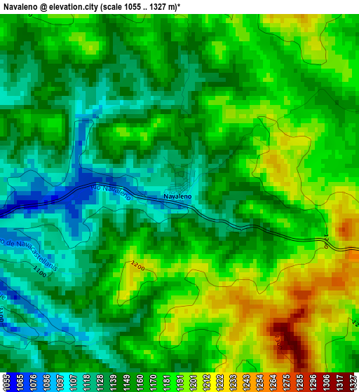
Below is the Elevation map of Navaleno, which displays elevation range with different colors. Scale of the first map is from 1055 to 1327 m (3461 to 4354 ft) with average elevation of 1161.4 meters (=3810 ft) [note 1]
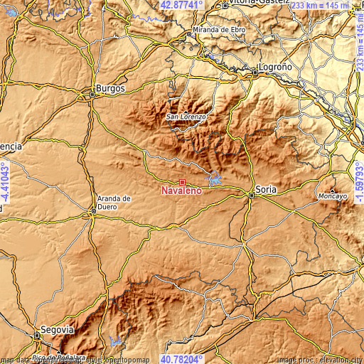
These maps also provides idea of topography and contour of this city, they are displayed at different zoom levels. More info about maps, scale and edge coordinates you can find below images.
| \ | Map #1 | Topo.Map |
| Scale [m] | 1055..1327 m | × |
| Scale [ft] | 3461..4354 ft | × |
| Average | 1161.4 m = 3810 ft | × |
| Width | 7.28 km = 4.5 mi | 233 km = 144.8 mi |
| Height | 7.28 km = 4.5 mi | 233 km = 144.8 mi |
| ↑Max Latitude | 41.871032° | 42.87741° |
| Latitude at center | 41.8383° | 41.8383° |
| ↓Min Latitude | 41.805551° | 40.78204° |
| ← Min Longitude | -3.048125° | -4.41043° |
| Longitude center | -3.00418° | -3.00418° |
| →Max Longitude | -2.960235° | -1.59793° |
Nearby cities:
Cities around Navaleno sort by population:
• San Leonardo de Yagüe elevation 1045 m
5.4 km,  260°
260°
• Hontoria del Pinar 1057 m
13.2 km,  274°
274°
• Vilviestre del Pinar 1144 m
13.9 km,  333°
333°
• Canicosa de la Sierra 1142 m
11.4 km,  344°
344°
• Cabrejas del Pinar 1155 m
13.7 km,  110°
110°
• Regumiel de la Sierra 1124 m
13.2 km,  5°
5°
• Casarejos 1085 m
5.2 km,  206°
206°
• Santa María de las Hoyas 1070 m
13.6 km,  236°
236°
• Vadillo 1106 m
5.3 km,  183°
183°
• Muriel Viejo 1089 m
9.6 km,  130°
130°
• Cubilla 1099 m
11.4 km,  150°
150°
• Herrera de Soria 1096 m
8.4 km, 184°
Multilingual:
 En español:
Navaleno elevación 1116 m.
 En France:
Navaleno élévation 1116 m.
 Auf Deutsch:
Navaleno höhe über dem Meeresspiegel ist 1116 m.

Sources and notes:
- [note 1] Map square and city borders are not equal. Map elevation data is calculated only from area inside that square.
- [src 1] Elevation data from geonames database provided with same terms of usage.
- [src 2] The elevation map of Navaleno is generated using elevation data from NASA's 3 arcsec (90m) resolution SRTM data.
- [src 3] Base (background) map © OpenStreetMap contributors tiles are generated by Geofabrik and OpenTopoMap.
Copyright & License:
This Navaleno Elevation Map is licensed under CC BY-SA. You may reuse any part from this page, if you give a proper credit by linking to this URL:
 More info on terms of use page.