Nigüella elevation
Nigüella (Aragon, Provincia de Zaragoza), Spain elevation is 481 meters and Nigüella elevation in feet is 1578 ft above sea level [src 1]. Nigüella is a seat of a third-order administrative division (feature code) with elevation that is 122 meters (400 ft) smaller than average city elevation in Spain.
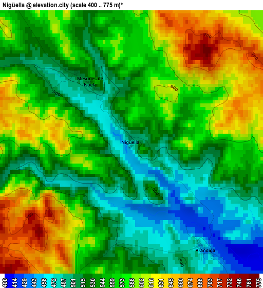
Below is the Elevation map of Nigüella, which displays elevation range with different colors. Scale of the first map is from 400 to 775 m (1312 to 2543 ft) with average elevation of 557.4 meters (=1829 ft) [note 1]
These maps also provides idea of topography and contour of this city, they are displayed at different zoom levels. More info about maps, scale and edge coordinates you can find below images.
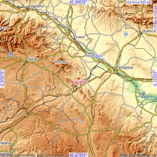
| \ | Map #1 | Topo.Map |
| Scale [m] | 400..775 m | × |
| Scale [ft] | 1312..2543 ft | × |
| Average | 557.4 m = 1829 ft | × |
| Width | 7.32 km = 4.5 mi | 234.1 km = 145.5 mi |
| Height | 7.32 km = 4.5 mi | 234.1 km = 145.5 mi |
| ↑Max Latitude | 41.569096° | 42.58026° |
| Latitude at center | 41.53621° | 41.53621° |
| ↓Min Latitude | 41.503307° | 40.47503° |
| ← Min Longitude | -1.568445° | -2.93075° |
| Longitude center | -1.5245° | -1.5245° |
| →Max Longitude | -1.480555° | -0.11825° |
Nearby cities:
Cities around Nigüella sort by population:
• Illueca elevation 588 m
8.6 km,  271°
271°
• Ricla 392 m
10.5 km,  108°
108°
• Brea de Aragón 559 m
6.6 km,  258°
258°
• Morata de Jalón 425 m
8 km,  150°
150°
• Jarque 642 m
12.8 km,  279°
279°
• Arándiga 443 m
3.6 km, 147°
• Sestrica 569 m
8.1 km,  226°
226°
• Morés 448 m
7.8 km,  205°
205°
• Gotor 612 m
10.4 km, 275°
• Mesones de Isuela 518 m
2 km,  324°
324°
• Paracuellos de la Ribera 499 m
13 km,  194°
194°
• Chodes 415 m
6.6 km, 145°
Multilingual:
 En español:
Nigüella elevación 481 m.
 En France:
Nigüella élévation 481 m.
 Auf Deutsch:
Nigüella höhe über dem Meeresspiegel ist 481 m.

Sources and notes:
- [note 1] Map square and city borders are not equal. Map elevation data is calculated only from area inside that square.
- [src 1] Elevation data from geonames database provided with same terms of usage.
- [src 2] The elevation map of Nigüella is generated using elevation data from NASA's 3 arcsec (90m) resolution SRTM data.
- [src 3] Base (background) map © OpenStreetMap contributors tiles are generated by Geofabrik and OpenTopoMap.
Copyright & License:
This Nigüella Elevation Map is licensed under CC BY-SA. You may reuse any part from this page, if you give a proper credit by linking to this URL:
 More info on terms of use page.