Niharra elevation
Niharra (Castille and León, Provincia de Ávila), Spain elevation is 1093 meters and Niharra elevation in feet is 3586 ft above sea level [src 1]. Niharra is a seat of a third-order administrative division (feature code) with elevation that is 490 meters (1608 ft) bigger than average city elevation in Spain.
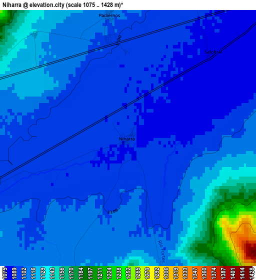
Below is the Elevation map of Niharra, which displays elevation range with different colors. Scale of the first map is from 1075 to 1428 m (3527 to 4685 ft) with average elevation of 1110.2 meters (=3642 ft) [note 1]
These maps also provides idea of topography and contour of this city, they are displayed at different zoom levels. More info about maps, scale and edge coordinates you can find below images.
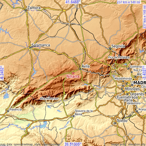
| \ | Map #1 | Topo.Map |
| Scale [m] | 1075..1428 m | × |
| Scale [ft] | 3527..4685 ft | × |
| Average | 1110.2 m = 3642 ft | × |
| Width | 7.42 km = 4.6 mi | 237.5 km = 147.6 mi |
| Height | 7.42 km = 4.6 mi | 237.5 km = 147.6 mi |
| ↑Max Latitude | 40.622813° | 41.6488° |
| Latitude at center | 40.58945° | 40.58945° |
| ↓Min Latitude | 40.55607° | 39.51305° |
| ← Min Longitude | -4.882895° | -6.2452° |
| Longitude center | -4.83895° | -4.83895° |
| →Max Longitude | -4.795005° | -3.4327° |
Nearby cities:
Cities around Niharra sort by population:
• Ávila elevation 1127 m
14 km,  57°
57°
• Solosancho 1126 m
6.9 km,  233°
233°
• Muñogalindo 1134 m
5.3 km,  286°
286°
• Sotalbo 1178 m
5.3 km,  185°
185°
• Padiernos 1106 m
3.6 km,  351°
351°
• Martiherrero 1228 m
10.6 km,  27°
27°
• Gemuño 1105 m
4.8 km,  87°
87°
• Sanchorreja 1312 m
10.5 km,  322°
322°
• Mironcillo 1129 m
4.1 km,  162°
162°
• Salobral 1087 m
3.5 km,  44°
44°
• Muñopepe 1125 m
5.2 km,  18°
18°
• Narrillos del Rebollar 1380 m
13.6 km,  308°
308°
Multilingual:
 En español:
Niharra elevación 1093 m.
 En France:
Niharra élévation 1093 m.
 Auf Deutsch:
Niharra höhe über dem Meeresspiegel ist 1093 m.

Sources and notes:
- [note 1] Map square and city borders are not equal. Map elevation data is calculated only from area inside that square.
- [src 1] Elevation data from geonames database provided with same terms of usage.
- [src 2] The elevation map of Niharra is generated using elevation data from NASA's 3 arcsec (90m) resolution SRTM data.
- [src 3] Base (background) map © OpenStreetMap contributors tiles are generated by Geofabrik and OpenTopoMap.
Copyright & License:
This Niharra Elevation Map is licensed under CC BY-SA. You may reuse any part from this page, if you give a proper credit by linking to this URL:
 More info on terms of use page.