Ojacastro elevation
Ojacastro (La Rioja, Provincia de La Rioja), Spain elevation is 790 meters and Ojacastro elevation in feet is 2592 ft above sea level [src 1]. Ojacastro is a seat of a third-order administrative division (feature code) with elevation that is 187 meters (614 ft) bigger than average city elevation in Spain.
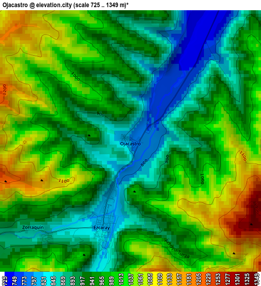
Below is the Elevation map of Ojacastro, which displays elevation range with different colors. Scale of the first map is from 725 to 1349 m (2379 to 4426 ft) with average elevation of 966.3 meters (=3170 ft) [note 1]
These maps also provides idea of topography and contour of this city, they are displayed at different zoom levels. More info about maps, scale and edge coordinates you can find below images.
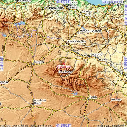
| \ | Map #1 | Topo.Map |
| Scale [m] | 725..1349 m | × |
| Scale [ft] | 2379..4426 ft | × |
| Average | 966.3 m = 3170 ft | × |
| Width | 7.22 km = 4.5 mi | 231.1 km = 143.6 mi |
| Height | 7.22 km = 4.5 mi | 231.1 km = 143.6 mi |
| ↑Max Latitude | 42.379671° | 43.37793° |
| Latitude at center | 42.3472° | 42.3472° |
| ↓Min Latitude | 42.314713° | 41.29929° |
| ← Min Longitude | -3.048845° | -4.41115° |
| Longitude center | -3.0049° | -3.0049° |
| →Max Longitude | -2.960955° | -1.59865° |
Nearby cities:
Cities around Ojacastro sort by population:
• Santo Domingo de la Calzada elevation 646 m
11.2 km,  22°
22°
• Ezcaray 816 m
2.5 km,  195°
195°
• Villarta-Quintana 754 m
9.9 km,  338°
338°
• Santurdejo 784 m
5.3 km,  51°
51°
• Valgañón 939 m
6.1 km,  237°
237°
• Fresneda de la Sierra Tirón 985 m
11.3 km,  251°
251°
• Manzanares de Rioja 803 m
10.5 km,  58°
58°
• Bascuñana 800 m
10.8 km,  323°
323°
• Zorraquín 866 m
3.7 km,  229°
229°
• Corporales 735 m
9.5 km,  4°
4°
• Pazuengos 1160 m
7.3 km,  116°
116°
• Villarejo 828 m
10.1 km,  72°
72°
Multilingual:
 En español:
Ojacastro elevación 790 m.
 En France:
Ojacastro élévation 790 m.
 Auf Deutsch:
Ojacastro höhe über dem Meeresspiegel ist 790 m.

Sources and notes:
- [note 1] Map square and city borders are not equal. Map elevation data is calculated only from area inside that square.
- [src 1] Elevation data from geonames database provided with same terms of usage.
- [src 2] The elevation map of Ojacastro is generated using elevation data from NASA's 3 arcsec (90m) resolution SRTM data.
- [src 3] Base (background) map © OpenStreetMap contributors tiles are generated by Geofabrik and OpenTopoMap.
Copyright & License:
This Ojacastro Elevation Map is licensed under CC BY-SA. You may reuse any part from this page, if you give a proper credit by linking to this URL:
 More info on terms of use page.