Olba elevation
Olba (Aragon, Provincia de Teruel), Spain elevation is 647 meters and Olba elevation in feet is 2123 ft above sea level [src 1]. Olba is a seat of a third-order administrative division (feature code) with elevation that is 44 meters (144 ft) bigger than average city elevation in Spain.
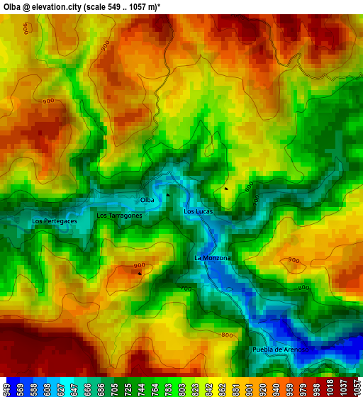
Below is the Elevation map of Olba, which displays elevation range with different colors. Scale of the first map is from 549 to 1057 m (1801 to 3468 ft) with average elevation of 825.8 meters (=2709 ft) [note 1]
These maps also provides idea of topography and contour of this city, they are displayed at different zoom levels. More info about maps, scale and edge coordinates you can find below images.
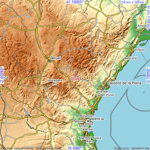
| \ | Map #1 | Topo.Map |
| Scale [m] | 549..1057 m | × |
| Scale [ft] | 1801..3468 ft | × |
| Average | 825.8 m = 2709 ft | × |
| Width | 7.47 km = 4.6 mi | 239.1 km = 148.6 mi |
| Height | 7.47 km = 4.6 mi | 239.1 km = 148.6 mi |
| ↑Max Latitude | 40.16692° | 41.19995° |
| Latitude at center | 40.13333° | 40.13333° |
| ↓Min Latitude | 40.099723° | 39.0497° |
| ← Min Longitude | -0.660615° | -2.02292° |
| Longitude center | -0.61667° | -0.61667° |
| →Max Longitude | -0.572725° | 0.78958° |
Nearby cities:
Cities around Olba sort by population:
• Rubielos de Mora elevation 938 m
6.9 km,  333°
333°
• Montanejos 461 m
11.3 km,  131°
131°
• Cortes de Arenoso 1006 m
8.8 km,  46°
46°
• Montán 573 m
12.5 km,  152°
152°
• Nogueruelas 1130 m
11.6 km,  351°
351°
• Puebla de Arenoso 740 m
4.7 km,  142°
142°
• Pina de Montalgrao 1024 m
13.3 km,  192°
192°
• Fuentes de Rubielos 942 m
3.7 km,  0°
0°
• San Agustín 912 m
10.5 km,  218°
218°
• Villanueva de Viver 968 m
9.7 km,  197°
197°
• Fuente la Reina 763 m
7.5 km,  169°
169°
• Albentosa 976 m
13.3 km,  255°
255°
Multilingual:
 En español:
Olba elevación 647 m.
 En France:
Olba élévation 647 m.


Sources and notes:
- [note 1] Map square and city borders are not equal. Map elevation data is calculated only from area inside that square.
- [src 1] Elevation data from geonames database provided with same terms of usage.
- [src 2] The elevation map of Olba is generated using elevation data from NASA's 3 arcsec (90m) resolution SRTM data.
- [src 3] Base (background) map © OpenStreetMap contributors tiles are generated by Geofabrik and OpenTopoMap.
Copyright & License:
This Olba Elevation Map is licensed under CC BY-SA. You may reuse any part from this page, if you give a proper credit by linking to this URL:
 More info on terms of use page.