Oña elevation
Oña (Castille and León, Provincia de Burgos), Spain elevation is 589 meters and Oña elevation in feet is 1932 ft above sea level [src 1]. Oña is a seat of a third-order administrative division (feature code) with elevation that is 14 meters (46 ft) smaller than average city elevation in Spain.
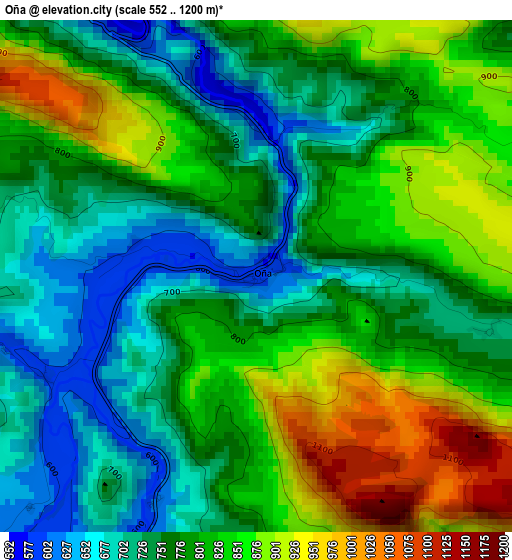
Below is the Elevation map of Oña, which displays elevation range with different colors. Scale of the first map is from 552 to 1200 m (1811 to 3937 ft) with average elevation of 792.8 meters (=2601 ft) [note 1]
These maps also provides idea of topography and contour of this city, they are displayed at different zoom levels. More info about maps, scale and edge coordinates you can find below images.
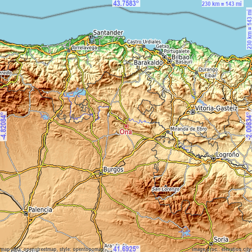
| \ | Map #1 | Topo.Map |
| Scale [m] | 552..1200 m | × |
| Scale [ft] | 1811..3937 ft | × |
| Average | 792.8 m = 2601 ft | × |
| Width | 7.18 km = 4.5 mi | 229.7 km = 142.7 mi |
| Height | 7.18 km = 4.5 mi | 229.7 km = 142.7 mi |
| ↑Max Latitude | 42.76627° | 43.7583° |
| Latitude at center | 42.734° | 42.734° |
| ↓Min Latitude | 42.701713° | 41.6925° |
| ← Min Longitude | -3.458535° | -4.82084° |
| Longitude center | -3.41459° | -3.41459° |
| →Max Longitude | -3.370645° | -2.00834° |
Nearby cities:
Cities around Oña sort by population:
• Trespaderne elevation 556 m
7.8 km,  14°
14°
• Poza de la Sal 764 m
10.4 km,  222°
222°
• Frías 583 m
10.3 km,  72°
72°
• Busto de Bureba 707 m
14.8 km,  124°
124°
• Salas de Bureba 631 m
6.7 km,  225°
225°
• Llano de Bureba 644 m
12.7 km,  196°
196°
• Quintanaélez 709 m
11.9 km,  127°
127°
• Rucandio 799 m
10.5 km,  280°
280°
• Padrones de Bureba 776 m
10.2 km,  252°
252°
• Navas de Bureba 752 m
9.3 km, 129°
• Cantabrana 635 m
4.3 km,  270°
270°
• Vileña 667 m
14.5 km,  148°
148°
Multilingual:
 En español:
Oña elevación 589 m.
 En France:
Oña élévation 589 m.


Sources and notes:
- [note 1] Map square and city borders are not equal. Map elevation data is calculated only from area inside that square.
- [src 1] Elevation data from geonames database provided with same terms of usage.
- [src 2] The elevation map of Oña is generated using elevation data from NASA's 3 arcsec (90m) resolution SRTM data.
- [src 3] Base (background) map © OpenStreetMap contributors tiles are generated by Geofabrik and OpenTopoMap.
Copyright & License:
This Oña Elevation Map is licensed under CC BY-SA. You may reuse any part from this page, if you give a proper credit by linking to this URL:
 More info on terms of use page.