Ortuella elevation
Ortuella (Basque Country, Bizkaia), Spain elevation is 80 meters and Ortuella elevation in feet is 262 ft above sea level [src 1]. Ortuella is a populated place (feature code) with elevation that is 523 meters (1716 ft) smaller than average city elevation in Spain.
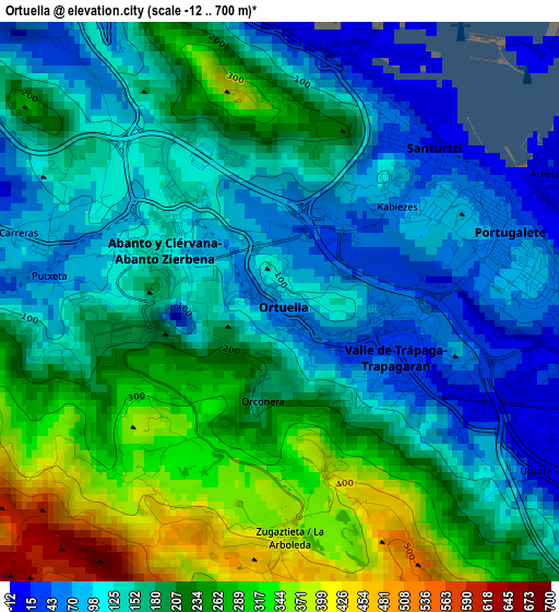
Below is the Elevation map of Ortuella, which displays elevation range with different colors. Scale of the first map is from -12 to 700 m (-39 to 2297 ft) with average elevation of 181.4 meters (=595 ft) [note 1]
These maps also provides idea of topography and contour of this city, they are displayed at different zoom levels. More info about maps, scale and edge coordinates you can find below images.
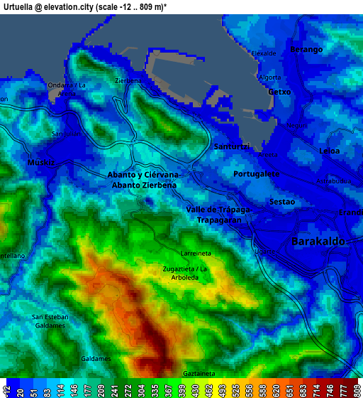
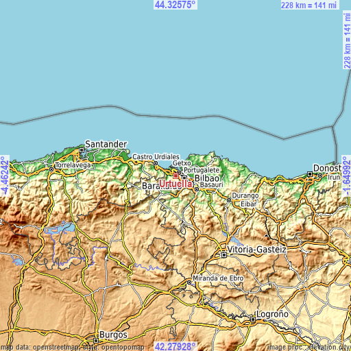
| \ | Map #1 | Map #2 | Topo.Map |
| Scale [m] | -12..700 m | -12..809 m | × |
| Scale [ft] | -39..2297 ft | -39..2654 ft | × |
| Average | 181.4 m = 595 ft | 170.4 m = 559 ft | × |
| Width | 7.11 km = 4.4 mi | 14.22 km = 8.8 mi | 227.5 km = 141.4 mi |
| Height | 7.11 km = 4.4 mi | 14.22 km = 8.8 mi | 227.5 km = 141.4 mi |
| ↑Max Latitude | 43.343098° | 43.375049° | 44.32575° |
| Latitude at center | 43.31113° | 43.31113° | 43.31113° |
| ↓Min Latitude | 43.279145° | 43.247144° | 42.27928° |
| ← Min Longitude | -3.100115° | -3.144061° | -4.46242° |
| Longitude center | -3.05617° | -3.05617° | -3.05617° |
| →Max Longitude | -3.012225° | -2.968279° | -1.64992° |
Nearby cities:
Cities around Ortuella sort by population:
• Barakaldo elevation 27 m
5.7 km,  106°
106°
• Algorta 51 m
5.7 km,  41°
41°
• Getxo 43 m
6.2 km, 35°
• Portugalete 49 m
3.1 km,  69°
69°
• Santurtzi 13 m
2.7 km, 44°
• Leioa 24 m
5.7 km, 72°
• Sestao 65 m
4 km,  92°
92°
• Erandio 9 m
6.7 km,  96°
96°
• Zierbena 46 m
4.8 km,  333°
333°
• Berango 27 m
7.7 km, 39°
• Alonsotegi 26 m
9.2 km,  143°
143°
• San Julián de Muskiz 143 m
4.3 km,  304°
304°
Multilingual:
 En español:
Ortuella elevación 80 m.
 En France:
Ortuella élévation 80 m.


Sources and notes:
- [note 1] Map square and city borders are not equal. Map elevation data is calculated only from area inside that square.
- [src 1] Elevation data from geonames database provided with same terms of usage.
- [src 2] The elevation map of Ortuella is generated using elevation data from NASA's 3 arcsec (90m) resolution SRTM data.
- [src 3] Base (background) map © OpenStreetMap contributors tiles are generated by Geofabrik and OpenTopoMap.
Copyright & License:
This Ortuella Elevation Map is licensed under CC BY-SA. You may reuse any part from this page, if you give a proper credit by linking to this URL:
 More info on terms of use page.