Peñarandilla elevation
Peñarandilla (Castille and León, Provincia de Salamanca), Spain elevation is 826 meters and Peñarandilla elevation in feet is 2710 ft above sea level [src 1]. Peñarandilla is a seat of a third-order administrative division (feature code) with elevation that is 223 meters (732 ft) bigger than average city elevation in Spain.
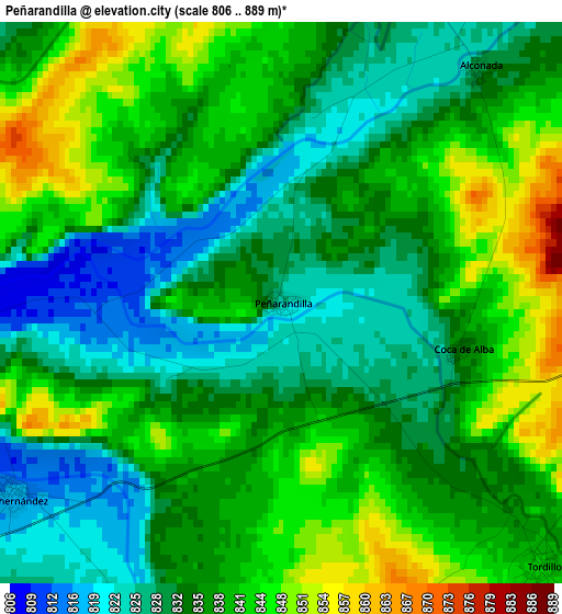
Below is the Elevation map of Peñarandilla, which displays elevation range with different colors. Scale of the first map is from 806 to 889 m (2644 to 2917 ft) with average elevation of 836 meters (=2743 ft) [note 1]
These maps also provides idea of topography and contour of this city, they are displayed at different zoom levels. More info about maps, scale and edge coordinates you can find below images.
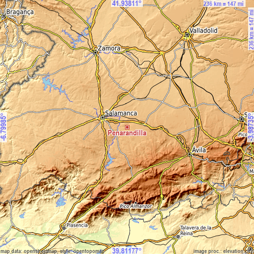
| \ | Map #1 | Topo.Map |
| Scale [m] | 806..889 m | × |
| Scale [ft] | 2644..2917 ft | × |
| Average | 836 m = 2743 ft | × |
| Width | 7.39 km = 4.6 mi | 236.4 km = 146.9 mi |
| Height | 7.39 km = 4.6 mi | 236.4 km = 146.9 mi |
| ↑Max Latitude | 40.916696° | 41.93811° |
| Latitude at center | 40.88348° | 40.88348° |
| ↓Min Latitude | 40.850247° | 39.81177° |
| ← Min Longitude | -5.437545° | -6.79985° |
| Longitude center | -5.3936° | -5.3936° |
| →Max Longitude | -5.349655° | -3.98735° |
Nearby cities:
Cities around Peñarandilla sort by population:
• Babilafuente elevation 800 m
10.7 km,  345°
345°
• Encinas de Abajo 794 m
8.6 km,  311°
311°
• Garcihernández 817 m
4.3 km,  234°
234°
• Tordillos 841 m
4.9 km,  134°
134°
• Villagonzalo de Tormes 804 m
8.7 km,  276°
276°
• Pedrosillo de Alba 837 m
6.8 km,  181°
181°
• Alconada 831 m
4 km,  40°
40°
• Nava de Sotrobal 857 m
9.1 km,  85°
85°
• Cordovilla 825 m
7.6 km, 351°
• Ventosa del Río Almar 856 m
6.2 km, 37°
• Coca de Alba 834 m
2.4 km,  103°
103°
• Aldeaseca de Alba 862 m
8.5 km,  212°
212°
Multilingual:
 En español:
Peñarandilla elevación 826 m.
 En France:
Peñarandilla élévation 826 m.
 Auf Deutsch:
Peñarandilla höhe über dem Meeresspiegel ist 826 m.

Sources and notes:
- [note 1] Map square and city borders are not equal. Map elevation data is calculated only from area inside that square.
- [src 1] Elevation data from geonames database provided with same terms of usage.
- [src 2] The elevation map of Peñarandilla is generated using elevation data from NASA's 3 arcsec (90m) resolution SRTM data.
- [src 3] Base (background) map © OpenStreetMap contributors tiles are generated by Geofabrik and OpenTopoMap.
Copyright & License:
This Peñarandilla Elevation Map is licensed under CC BY-SA. You may reuse any part from this page, if you give a proper credit by linking to this URL:
 More info on terms of use page.