Pinarnegrillo elevation
Pinarnegrillo (Castille and León, Provincia de Segovia), Spain elevation is 855 meters and Pinarnegrillo elevation in feet is 2805 ft above sea level [src 1]. Pinarnegrillo is a seat of a third-order administrative division (feature code) with elevation that is 252 meters (827 ft) bigger than average city elevation in Spain.
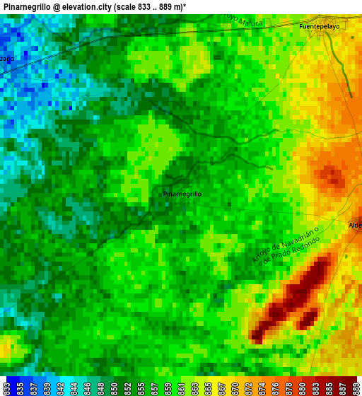
Below is the Elevation map of Pinarnegrillo, which displays elevation range with different colors. Scale of the first map is from 833 to 889 m (2733 to 2917 ft) with average elevation of 857.9 meters (=2815 ft) [note 1]
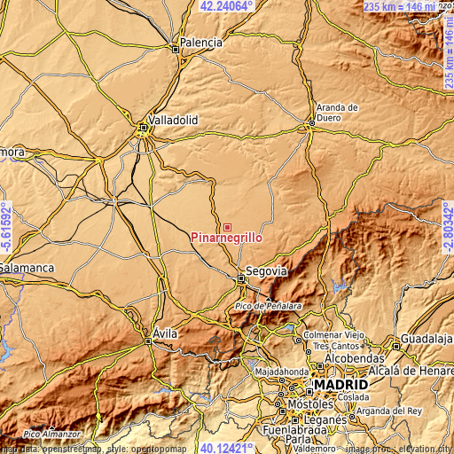
These maps also provides idea of topography and contour of this city, they are displayed at different zoom levels. More info about maps, scale and edge coordinates you can find below images.
| \ | Map #1 | Topo.Map |
| Scale [m] | 833..889 m | × |
| Scale [ft] | 2733..2917 ft | × |
| Average | 857.9 m = 2815 ft | × |
| Width | 7.35 km = 4.6 mi | 235.3 km = 146.2 mi |
| Height | 7.35 km = 4.6 mi | 235.3 km = 146.2 mi |
| ↑Max Latitude | 41.224041° | 42.24064° |
| Latitude at center | 41.19098° | 41.19098° |
| ↓Min Latitude | 41.157902° | 40.12421° |
| ← Min Longitude | -4.253615° | -5.61592° |
| Longitude center | -4.20967° | -4.20967° |
| →Max Longitude | -4.165725° | -2.80342° |
Nearby cities:
Cities around Pinarnegrillo sort by population:
• Carbonero el Mayor elevation 915 m
8.9 km,  211°
211°
• Navalmanzano 838 m
4.8 km,  305°
305°
• Mozoncillo 860 m
5.4 km,  159°
159°
• Fuentepelayo 869 m
4.5 km,  39°
39°
• Aguilafuente 890 m
9.1 km,  64°
64°
• Escalona del Prado 894 m
7.8 km,  110°
110°
• Zarzuela del Pinar 880 m
8 km,  15°
15°
• Aldea Real 883 m
3.7 km,  99°
99°
• Escarabajosa de Cabezas 883 m
9.7 km,  172°
172°
• Sauquillo de Cabezas 909 m
11.8 km,  88°
88°
• Pinarejos 822 m
10.4 km,  317°
317°
• Tabanera la Luenga 906 m
10.8 km,  193°
193°
Multilingual:
 En español:
Pinarnegrillo elevación 855 m.
 En France:
Pinarnegrillo élévation 855 m.
 Auf Deutsch:
Pinarnegrillo höhe über dem Meeresspiegel ist 855 m.

Sources and notes:
- [note 1] Map square and city borders are not equal. Map elevation data is calculated only from area inside that square.
- [src 1] Elevation data from geonames database provided with same terms of usage.
- [src 2] The elevation map of Pinarnegrillo is generated using elevation data from NASA's 3 arcsec (90m) resolution SRTM data.
- [src 3] Base (background) map © OpenStreetMap contributors tiles are generated by Geofabrik and OpenTopoMap.
Copyright & License:
This Pinarnegrillo Elevation Map is licensed under CC BY-SA. You may reuse any part from this page, if you give a proper credit by linking to this URL:
 More info on terms of use page.