Pizarral elevation
Pizarral (Castille and León, Provincia de Salamanca), Spain elevation is 906 meters and Pizarral elevation in feet is 2972 ft above sea level [src 1]. Pizarral is a seat of a third-order administrative division (feature code) with elevation that is 303 meters (994 ft) bigger than average city elevation in Spain.
Below is the Elevation map of Pizarral, which displays elevation range with different colors. Scale of the first map is from 851 to 992 m (2792 to 3255 ft) with average elevation of 925.8 meters (=3037 ft) [note 1]
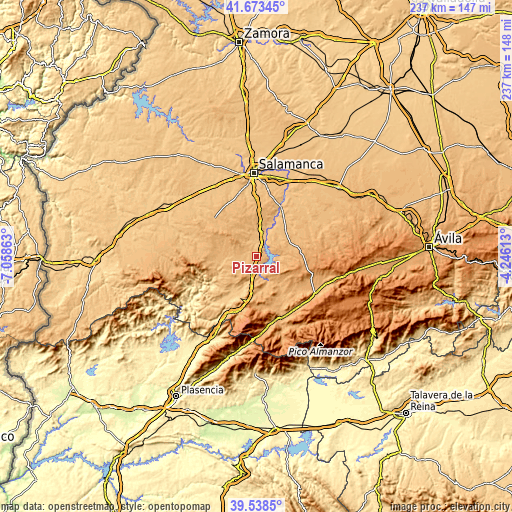
These maps also provides idea of topography and contour of this city, they are displayed at different zoom levels. More info about maps, scale and edge coordinates you can find below images.
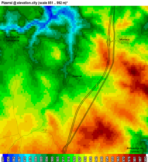
| \ | Map #1 | Topo.Map |
| Scale [m] | 851..992 m | × |
| Scale [ft] | 2792..3255 ft | × |
| Average | 925.8 m = 3037 ft | × |
| Width | 7.42 km = 4.6 mi | 237.4 km = 147.5 mi |
| Height | 7.42 km = 4.6 mi | 237.4 km = 147.5 mi |
| ↑Max Latitude | 40.647851° | 41.67345° |
| Latitude at center | 40.6145° | 40.6145° |
| ↓Min Latitude | 40.581132° | 39.5385° |
| ← Min Longitude | -5.696325° | -7.05863° |
| Longitude center | -5.65238° | -5.65238° |
| →Max Longitude | -5.608435° | -4.24613° |
Nearby cities:
Cities around Pizarral sort by population:
• Guijuelo elevation 1009 m
6.5 km,  193°
193°
• Galinduste 953 m
10.9 km,  60°
60°
• Pedrosillo de los Aires 961 m
12.1 km,  338°
338°
• Fuenterroble de Salvatierra 951 m
8.8 km,  231°
231°
• Frades de la Sierra 954 m
11.9 km,  293°
293°
• Montejo 931 m
3.2 km,  51°
51°
• Pelayos 930 m
7.6 km, 58°
• Aldeavieja de Tormes 910 m
4.6 km,  139°
139°
• Berrocal de Salvatierra 900 m
3.8 km,  303°
303°
• Guijo de Ávila 977 m
9.4 km,  173°
173°
• Casafranca 930 m
9.4 km,  255°
255°
• Salvatierra de Tormes 906 m
5.4 km,  120°
120°
Multilingual:
 En español:
Pizarral elevación 906 m.
 En France:
Pizarral élévation 906 m.
 Auf Deutsch:
Pizarral höhe über dem Meeresspiegel ist 906 m.

Sources and notes:
- [note 1] Map square and city borders are not equal. Map elevation data is calculated only from area inside that square.
- [src 1] Elevation data from geonames database provided with same terms of usage.
- [src 2] The elevation map of Pizarral is generated using elevation data from NASA's 3 arcsec (90m) resolution SRTM data.
- [src 3] Base (background) map © OpenStreetMap contributors tiles are generated by Geofabrik and OpenTopoMap.
Copyright & License:
This Pizarral Elevation Map is licensed under CC BY-SA. You may reuse any part from this page, if you give a proper credit by linking to this URL:
 More info on terms of use page.