Planoles elevation
Planoles (Catalonia, Província de Girona), Spain elevation is 1142 meters and Planoles elevation in feet is 3747 ft above sea level [src 1]. Planoles is a seat of a third-order administrative division (feature code) with elevation that is 539 meters (1768 ft) bigger than average city elevation in Spain.
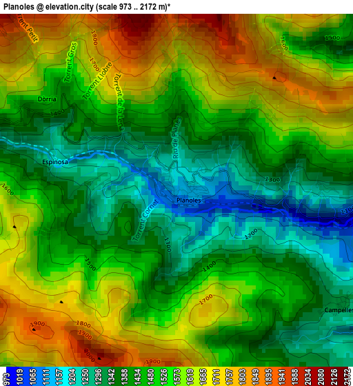
Below is the Elevation map of Planoles, which displays elevation range with different colors. Scale of the first map is from 973 to 2172 m (3192 to 7126 ft) with average elevation of 1510.5 meters (=4956 ft) [note 1]
These maps also provides idea of topography and contour of this city, they are displayed at different zoom levels. More info about maps, scale and edge coordinates you can find below images.
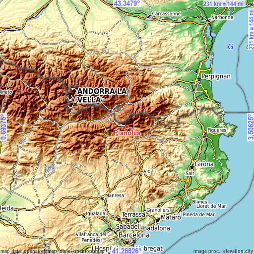
| \ | Map #1 | Topo.Map |
| Scale [m] | 973..2172 m | × |
| Scale [ft] | 3192..7126 ft | × |
| Average | 1510.5 m = 4956 ft | × |
| Width | 7.23 km = 4.5 mi | 231.2 km = 143.7 mi |
| Height | 7.23 km = 4.5 mi | 231.2 km = 143.7 mi |
| ↑Max Latitude | 42.349156° | 43.3479° |
| Latitude at center | 42.31667° | 42.31667° |
| ↓Min Latitude | 42.284167° | 41.26826° |
| ← Min Longitude | 2.056055° | 0.69375° |
| Longitude center | 2.1° | 2.1° |
| →Max Longitude | 2.143945° | 3.50625° |
Nearby cities:
Cities around Planoles sort by population:
• Ripoll elevation 697 m
14.9 km,  150°
150°
• Puigcerdà 1212 m
19 km,  312°
312°
• Sant Joan de les Abadesses 779 m
17.8 km,  121°
121°
• Campdevànol 739 m
11.7 km, 151°
• Ribes de Freser 913 m
5.7 km,  104°
104°
• Sant Julià de Cerdanyola 965 m
19.9 km,  238°
238°
• Guardiola de Berguedà 734 m
20.5 km, 243°
• Das 1222 m
19.5 km,  284°
284°
• Llívia 1217 m
19.1 km,  329°
329°
• Alp 1173 m
18.6 km,  289°
289°
• les Llosses 901 m
18.6 km,  175°
175°
• Toses 1447 m
6.9 km,  274°
274°
Multilingual:
 En español:
Planolas elevación 1142 m.
 En France:
Planoles élévation 1142 m.
 Auf Deutsch:
Planoles höhe über dem Meeresspiegel ist 1142 m.

Sources and notes:
- [note 1] Map square and city borders are not equal. Map elevation data is calculated only from area inside that square.
- [src 1] Elevation data from geonames database provided with same terms of usage.
- [src 2] The elevation map of Planoles is generated using elevation data from NASA's 3 arcsec (90m) resolution SRTM data.
- [src 3] Base (background) map © OpenStreetMap contributors tiles are generated by Geofabrik and OpenTopoMap.
Copyright & License:
This Planoles Elevation Map is licensed under CC BY-SA. You may reuse any part from this page, if you give a proper credit by linking to this URL:
 More info on terms of use page.