Pontils elevation
Pontils (Catalonia, Província de Tarragona), Spain elevation is 556 meters and Pontils elevation in feet is 1824 ft above sea level [src 1]. Pontils is a seat of a third-order administrative division (feature code) with elevation that is 47 meters (154 ft) smaller than average city elevation in Spain.
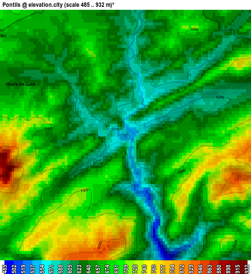
Below is the Elevation map of Pontils, which displays elevation range with different colors. Scale of the first map is from 485 to 932 m (1591 to 3058 ft) with average elevation of 665.2 meters (=2182 ft) [note 1]
These maps also provides idea of topography and contour of this city, they are displayed at different zoom levels. More info about maps, scale and edge coordinates you can find below images.
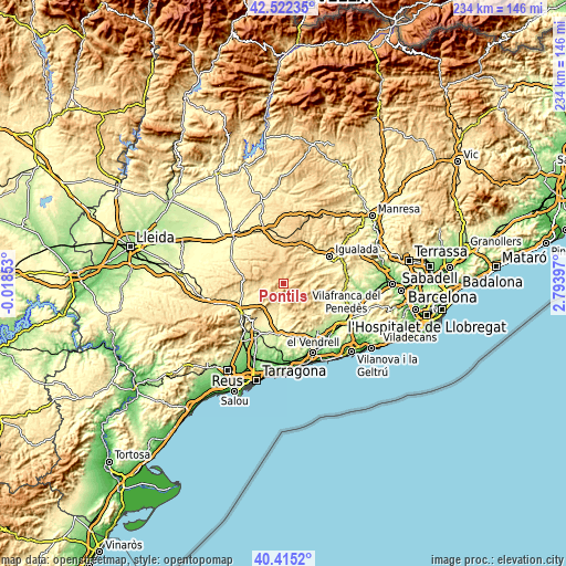
| \ | Map #1 | Topo.Map |
| Scale [m] | 485..932 m | × |
| Scale [ft] | 1591..3058 ft | × |
| Average | 665.2 m = 2182 ft | × |
| Width | 7.32 km = 4.5 mi | 234.3 km = 145.6 mi |
| Height | 7.32 km = 4.5 mi | 234.3 km = 145.6 mi |
| ↑Max Latitude | 41.510256° | 42.52235° |
| Latitude at center | 41.47734° | 41.47734° |
| ↓Min Latitude | 41.444407° | 40.4152° |
| ← Min Longitude | 1.343775° | -0.01853° |
| Longitude center | 1.38772° | 1.38772° |
| →Max Longitude | 1.431665° | 2.79397° |
Nearby cities:
Cities around Pontils sort by population:
• El Pla de Santa Maria elevation 381 m
15 km,  212°
212°
• Mediona 445 m
18.7 km,  89°
89°
• Querol 537 m
6.1 km,  172°
172°
• Orpí 488 m
16.3 km,  73°
73°
• Bellprat 637 m
5.8 km,  40°
40°
• Vallfogona de Riucorb 585 m
15.7 km,  307°
307°
• Argensola 653 m
14.2 km,  19°
19°
• Sant Martí de Tous 471 m
13.4 km,  53°
53°
• Forès 622 m
12.9 km,  272°
272°
• Cabra del Camp 501 m
12.2 km,  225°
225°
• Conesa 728 m
8.5 km,  300°
300°
• Santa Coloma de Queralt 682 m
6.2 km,  356°
356°
Multilingual:
 En español:
Pontils elevación 556 m.
 En France:
Pontils élévation 556 m.


Sources and notes:
- [note 1] Map square and city borders are not equal. Map elevation data is calculated only from area inside that square.
- [src 1] Elevation data from geonames database provided with same terms of usage.
- [src 2] The elevation map of Pontils is generated using elevation data from NASA's 3 arcsec (90m) resolution SRTM data.
- [src 3] Base (background) map © OpenStreetMap contributors tiles are generated by Geofabrik and OpenTopoMap.
Copyright & License:
This Pontils Elevation Map is licensed under CC BY-SA. You may reuse any part from this page, if you give a proper credit by linking to this URL:
 More info on terms of use page.