Priego elevation
Priego (Castille-La Mancha, Provincia de Cuenca), Spain elevation is 863 meters and Priego elevation in feet is 2831 ft above sea level [src 1]. Priego is a seat of a third-order administrative division (feature code) with elevation that is 260 meters (853 ft) bigger than average city elevation in Spain.
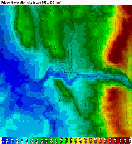
Below is the Elevation map of Priego, which displays elevation range with different colors. Scale of the first map is from 757 to 1301 m (2484 to 4268 ft) with average elevation of 931.2 meters (=3055 ft) [note 1]
These maps also provides idea of topography and contour of this city, they are displayed at different zoom levels. More info about maps, scale and edge coordinates you can find below images.
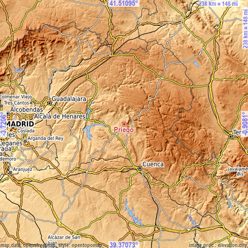
| \ | Map #1 | Topo.Map |
| Scale [m] | 757..1301 m | × |
| Scale [ft] | 2484..4268 ft | × |
| Average | 931.2 m = 3055 ft | × |
| Width | 7.44 km = 4.6 mi | 238 km = 147.9 mi |
| Height | 7.44 km = 4.6 mi | 238 km = 147.9 mi |
| ↑Max Latitude | 40.482793° | 41.51095° |
| Latitude at center | 40.44936° | 40.44936° |
| ↓Min Latitude | 40.41591° | 39.37073° |
| ← Min Longitude | -2.358295° | -3.7206° |
| Longitude center | -2.31435° | -2.31435° |
| →Max Longitude | -2.270405° | -0.9081° |
Nearby cities:
Cities around Priego sort by population:
• Cañamares elevation 888 m
6.3 km,  87°
87°
• Cañizares 1061 m
12.9 km,  53°
53°
• Villaconejos de Trabaque 814 m
5.4 km,  184°
184°
• Cañaveras 821 m
12.1 km,  214°
214°
• Albalate de las Nogueras 844 m
9.8 km,  161°
161°
• Valdeolivas 929 m
12.7 km,  299°
299°
• La Frontera 977 m
9.8 km,  122°
122°
• Albendea 838 m
9.7 km, 295°
• Fuertescusa 987 m
12 km,  76°
76°
• Alcantud 847 m
11.1 km,  352°
352°
• San Pedro Palmiches 830 m
8.1 km,  254°
254°
• Arandilla del Arroyo 893 m
9 km,  319°
319°
Multilingual:
 En español:
Priego elevación 863 m.
 En France:
Priego élévation 863 m.


Sources and notes:
- [note 1] Map square and city borders are not equal. Map elevation data is calculated only from area inside that square.
- [src 1] Elevation data from geonames database provided with same terms of usage.
- [src 2] The elevation map of Priego is generated using elevation data from NASA's 3 arcsec (90m) resolution SRTM data.
- [src 3] Base (background) map © OpenStreetMap contributors tiles are generated by Geofabrik and OpenTopoMap.
Copyright & License:
This Priego Elevation Map is licensed under CC BY-SA. You may reuse any part from this page, if you give a proper credit by linking to this URL:
 More info on terms of use page.