Ponte Caldelas elevation
Ponte Caldelas (Galicia, Provincia de Pontevedra), Spain elevation is 291 meters and Ponte Caldelas elevation in feet is 955 ft above sea level [src 1]. Ponte Caldelas is a seat of a third-order administrative division (feature code) with elevation that is 312 meters (1024 ft) smaller than average city elevation in Spain.
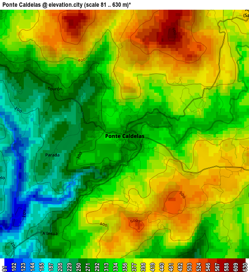
Below is the Elevation map of Ponte Caldelas, which displays elevation range with different colors. Scale of the first map is from 81 to 630 m (266 to 2067 ft) with average elevation of 351 meters (=1152 ft) [note 1]
These maps also provides idea of topography and contour of this city, they are displayed at different zoom levels. More info about maps, scale and edge coordinates you can find below images.
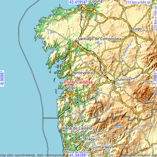
| \ | Map #1 | Topo.Map |
| Scale [m] | 81..630 m | × |
| Scale [ft] | 266..2067 ft | × |
| Average | 351 m = 1152 ft | × |
| Width | 7.22 km = 4.5 mi | 231 km = 143.5 mi |
| Height | 7.22 km = 4.5 mi | 231 km = 143.5 mi |
| ↑Max Latitude | 42.421559° | 43.41914° |
| Latitude at center | 42.38911° | 42.38911° |
| ↓Min Latitude | 42.356644° | 41.34189° |
| ← Min Longitude | -8.546295° | -9.9086° |
| Longitude center | -8.50235° | -8.50235° |
| →Max Longitude | -8.458405° | -7.0961° |
Nearby cities:
Cities around Ponte Caldelas sort by population:
• Pontevedra elevation 29 m
12.6 km,  291°
291°
• Redondela 6 m
14.7 km,  216°
216°
• Marín 39 m
16.3 km,  270°
270°
• Poio 44 m
16.4 km, 293°
• Mondariz 101 m
17.9 km,  168°
168°
• Moraña 212 m
19.1 km,  339°
339°
• Lama 493 m
5.8 km,  77°
77°
• Avión 549 m
20.7 km,  91°
91°
• Fornelos de Montes 326 m
6.7 km,  142°
142°
• Combarro 12 m
17.4 km, 285°
• Mondariz-Balneario 58 m
18.3 km, 170°
• Poio 14 m
13.8 km, 288°
Multilingual:
 En español:
Ponte Caldelas elevación 291 m.
 En France:
Ponte Caldelas élévation 291 m.
 Auf Deutsch:
Ponte Caldelas höhe über dem Meeresspiegel ist 291 m.

Sources and notes:
- [note 1] Map square and city borders are not equal. Map elevation data is calculated only from area inside that square.
- [src 1] Elevation data from geonames database provided with same terms of usage.
- [src 2] The elevation map of Ponte Caldelas is generated using elevation data from NASA's 3 arcsec (90m) resolution SRTM data.
- [src 3] Base (background) map © OpenStreetMap contributors tiles are generated by Geofabrik and OpenTopoMap.
Copyright & License:
This Ponte Caldelas Elevation Map is licensed under CC BY-SA. You may reuse any part from this page, if you give a proper credit by linking to this URL:
 More info on terms of use page.